词条 导航
描述: 导航是确定自己在地球或太空中的位置、预定的行进方向以及如何到达目的地的过程。在历史上,太阳和星星在导航中起到了重要作用。最简单的情况,在北半球的晴朗夜晚,可以通过北极星确定北方的位置,并据此选择行进方向;而在南半球,南十字星指向的是南方。在现代导航设备发展之前,“天体导航”是导航的关键方法。导航员会通过测量中午太阳在地平线上的角度来推算自己的纬度,并通过比较当地中午时间(太阳位于天空最高点的时间)与显示格林威治标准时间的时钟,来确定自己的经度。现代导航主要依赖于GPS及类似卫星系统的信号。
相关词条
用其他语言查看该词条
词条和定义状态: 该术语的英文原始定义已通过天文研究人员和教师的审核 该术语及其定义的译文仍待审核
OAE多语言词汇表是由国际天文学联合会(IAU) 天文教育办公室(OAE) 和 国际天文学联合会(IAU) 天文推广办公室(OAO)合作的项目。. 术语和定义由 OAE中心, OAE 国家天文教育协调员(NAECs) 以及其他志愿者共同选择、撰写和审阅。您可以在 找到完整的致谢列表。所有词汇表术语及其定义均根据 Creative Commons CC BY-4.0许可证发布 且版权归属于 “IAU OAE”。
如果您发现此词汇术语或定义中的事实或翻译错误, 请向 发邮件 联系.
其他语言版本
- 阿拉伯语: الملاحة
- 德语: Navigation
- 英语: Navigation
- 西班牙语: Navegación
- 法语: Navigation
- 意大利语: Navigazione
- 尼泊尔语: नेभिगेसन / दिशानिर्देशन
- 巴西葡萄牙语: Navegação
- 繁体中文: 導航
相关媒体
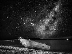
扬帆天海
图注: 在这张于2022年4月用智能手机拍摄的黑白照片,一叶孤舟停靠在澳大利亚尤坎本湖畔,被银河系的璀璨星空所衬托。银心的耀眼光芒在夜空中格外醒目,其星云与恒星交织的复杂图案形成了鲜明的对比。每一颗闪耀的光点都是一颗遥远的恒星,或许周围还环绕着未被探索的行星,突显了我们广袤而复杂的银河家园的浩瀚。
来源: 胡韵希/国际天文学联合会教育办公室 (CC BY 4.0)
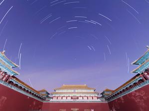
故宫星轨
图注: 2022 年 3 月拍摄的这张照片中,北京故宫矗立在星轨编织的夜空芭蕾之下,见证着古老的天体之间的联系。紫禁城在设计时考虑到了宇宙的排列,呼应了北极星的方位,北极星又叫 Polaris,是长期以来指引航海者的天体之锚,象征着天空的稳定。人们相信皇帝是北极星在人间的化身,是连接天地的桥梁。在这张用智能手机拍摄的和谐的一小时曝光照片中,星星的轨迹描绘了它们夜间穿越苍穹的旅程,它们向北极星汇聚,体现了建筑设计和天体轨迹的精确性。
来源: Stephanie Ziyi Ye/IAU OAE (CC BY 4.0)
相关活动
What is a Constellation?
astroEDU educational activity (links to astroEDU website) Description: Investigate three dimensional objects and perspective using constellations
License: CC-BY-4.0 知识共享许可协议 署名 4.0 国际 (CC BY 4.0) 图标
标签:
Hands-on
年龄段:
6-8
, 8-10
受教育等级:
Primary
学习领域:
建模
, 结构化探究式学习
费用:
中等成本
时间跨度:
1 小时 30 分钟
组别大小:
小组
技能:
分析和解读数据
, 提出问题
, 构建解释
, 开发和使用模型
How To Travel on Earth Without Getting Lost
astroEDU educational activity (links to astroEDU website) Description: Use a globe to describe your position on Earth.
License: CC-BY-4.0 知识共享许可协议 署名 4.0 国际 (CC BY 4.0) 图标
标签:
Geography
, Maps
, GPS
, Celestial navigation
年龄段:
8-10
, 10-12
, 12-14
受教育等级:
初中
, Primary
学习领域:
结构化探究式学习
费用:
低成本
时间跨度:
1 小时
组别大小:
小组
技能:
分析和解读数据
, 开发和使用模型
, 使用数学和计算思维
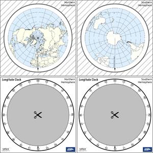
The Quest for Longitude
astroEDU educational activity (links to astroEDU website) Description: How to navigate at sea like an explorer?
License: CC-BY-4.0 知识共享许可协议 署名 4.0 国际 (CC BY 4.0) 图标
标签:
Clocks
, Geography
, Coordinates
, Celestial navigation
, James Cook
, Exploration
年龄段:
14-16
, 16-19
受教育等级:
初中
, 中学
学习领域:
讨论小组
, 建模
, 结构化探究式学习
费用:
低成本
时间跨度:
2 小时
组别大小:
小组
技能:
分析和解读数据
, 提出问题
, 传达信息
, 开发和使用模型
, 规划并开展调查
, 使用数学和计算思维
Where on Earth am I?
astroEDU educational activity (links to astroEDU website) Description: How do satellite-based positioning and GPS navigation work?
License: CC-BY-4.0 知识共享许可协议 署名 4.0 国际 (CC BY 4.0) 图标
标签:
Clocks
, Geography
, Maps
, GPS
, Countries
, Speed of light
, Galileo
年龄段:
14-16
受教育等级:
初中
学习领域:
引导式发现学习
, 问题解决
费用:
低成本
时间跨度:
1 小时 30 分钟
组别大小:
小组
技能:
分析和解读数据
, 提出问题
, 传达信息
, 构建解释
, 开发和使用模型
, 使用数学和计算思维
Navigate like a Viking – Use the Sun, not your phone!
astroEDU educational activity (links to astroEDU website) Description: Learn how the Vikings used the sky to navigate at sea with a hands-on activity!
License: CC-BY-4.0 知识共享许可协议 署名 4.0 国际 (CC BY 4.0) 图标
标签:
History
, Geography
, Maps
, Coordinates
, Celestial navigation
年龄段:
12-14
, 14-16
受教育等级:
初中
学习领域:
讨论小组
, 建模
, 结构化探究式学习
费用:
中等成本
时间跨度:
1 小时 30 分钟
组别大小:
小组
技能:
分析和解读数据
, 提出问题
, 传达信息
, 开发和使用模型
, 规划并开展调查
, 使用数学和计算思维

