Glossar-Begriff: Navigation
Beschreibung: Bei der Navigation geht es darum, herauszufinden, wo auf der Erde oder im Weltraum man sich befindet, in welche Richtung man reisen will und wie man an sein Ziel kommt. Früher spielten die Sonne und die Sterne eine wichtige Rolle für die Navigation. Ein einfaches Beispiel: Man befindet sich in einer klaren Nacht auf der Nordhalbkugel, kann mithilfe des Polarsterns herausfinden, wo Norden ist und sich dementsprechend orientieren. Auf der Südhalbkugel zeigt das Kreuz des Südens nach Süden. Vor der Entwicklung moderner Navigationsgeräte war die "Himmelsnavigation" für die Navigation unerlässlich. Seefahrer bestimmten den Winkel der Sonne über dem Horizont zur Mittagszeit, um ihren Breitengrad zu ermitteln. Um ihren Längengrad zu bestimmen, verglichen sie den Zeitpunkt der lokalen Mittagszeit (höchster Stand der Sonne am Himmel) mit einer Uhr, welche die Greenwich Mean Time (die mittlere Sonnenzeit am Greenwich-Nullmeridian) anzeigt. Die moderne Navigation verwendet hauptsächlich GPS-Signale und ähnliche Satellitensysteme.
Ähnliche Begriffe:
Dieser Begriff in anderen Sprachen
Begriffs- und Definitionsstatus Die Originaldefinition dieses Begriffes auf Englisch wurden von einem forschenden Astronom und einer Lehrkraft bestätigt Die Übersetzung dieses Begriffs und seiner Definition warten auf Prüfung und Bestätigung
The OAE Multilingual Glossary is a project of the IAU Office of Astronomy for Education (OAE) in collaboration with the IAU Office of Astronomy Outreach (OAO). The terms and definitions were chosen, written and reviewed by a collective effort from the OAE, the OAE Centers and Nodes, the OAE National Astronomy Education Coordinators (NAECs) and other volunteers. You can find a full list of credits here. All glossary terms and their definitions are released under a Creative Commons CC BY-4.0 license and should be credited to "IAU OAE".
Wenn dir ein inhaltlicher oder Übersetzungsfehler in diesem Glossarbegriff oder dieser Definition auffallen, bitte kontaktiere uns.
Auf anderen Sprachen
- Arabisch: الملاحة
- Englisch: Navigation
- Spanisch: Navegación
- Französisch: Navigation
- Italienisch: Navigazione
- Nepali: नेभिगेसन / दिशानिर्देशन
- Brasilianisches Portugiesisch: Navegação
- Vereinfachtes Chinesisch: 导航
- Traditionelles Chinesisch: 導航
Ähnliche Medien
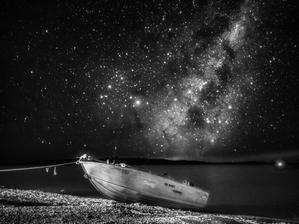
Segeln auf den himmlischen Meeren
Unterschrift: Auf diesem Schwarz-Weiß-Schnappschuss, der im April 2022 mit einem Smartphone aufgenommen wurde, ruht ein einsames Boot am Ufer des Eucumbene-Sees in Australien, umrahmt von dem brillanten Sternenhimmel der Milchstraße. Das auffällige Leuchten des galaktischen Zentrums hebt sich vom Nachthimmel ab, dessen verschlungene Muster aus Sternen und Nebeln einen starken Kontrast bilden. Jeder schimmernde Punkt steht für eine weit entfernte Sonne, die möglicherweise von unbekannten Planeten umkreist wird, und unterstreicht die Weite und Komplexität unserer ausgedehnten Heimatgalaxie.
Bild: Lucy Yunxi Hu/IAU OAE (CC BY 4.0)
License: CC-BY-4.0 Creative Commons Namensnennung 4.0 International (CC BY 4.0) Symbole
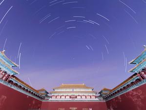
Strichspuren der Verbotenen Stadt
Unterschrift: Unter dem himmlischen Ballett der Strichspuren von Sternen, die sich um den Nachthimmel winden, liegt in diesem Bild, das im März 2022 aufgenommen wurde, die Verbotene Stadt in Peking als Zeugnis alter himmlischer Verbindungen. Der Palast wurde nach kosmischen Gesichtspunkten entworfen und orientiert sich an der Ausrichtung des Polarsterns, der auch Polaris genannt wird: einem himmlischen Anker, der seit langem in der Seefahrt den Weg weist und die Stabilität des Himmels symbolisiert. Man glaubte, dass der Kaiser das irdische Abbild dieses Polarsterns verkörperte und die Brücke zwischen Himmel und Erde schlug. In dieser harmonischen einstündigen Belichtung, die mit einem Smartphone entstanden ist, zeichnen die Spuren der Sterne ihre nächtliche Reise über das Firmament um den Polarstern nach und geben die Präzision sowohl der architektonischen Gestaltung als auch der himmlischen Pfade wider.
Bild: Stephanie Ziyi Ye/IAU OAE (CC BY 4.0)
License: CC-BY-4.0 Creative Commons Namensnennung 4.0 International (CC BY 4.0) Symbole
Ähnliche Aktivitäten
What is a Constellation?
astroEDU educational activity (links to astroEDU website) Description: Investigate three dimensional objects and perspective using constellations
License: CC-BY-4.0 Creative Commons Namensnennung 4.0 International (CC BY 4.0) Symbole
Schlagworte
Hands-on
Altersgruppen:
6-8
, 8-10
Bildungsniveau:
Primary
Lernbereiche:
Modelling
, Structured-inquiry learning
Kosten:
Medium Cost
Dauer:
1 hour 30 mins
Gruppengröße:
Group
Fähigkeiten:
Analysing and interpreting data
, Asking questions
, Constructing explanations
, Developing and using models
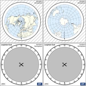
How To Travel on Earth Without Getting Lost
astroEDU educational activity (links to astroEDU website) Description: Use a globe to describe your position on Earth.
License: CC-BY-4.0 Creative Commons Namensnennung 4.0 International (CC BY 4.0) Symbole
Schlagworte
Geography
, Maps
, GPS
, Celestial navigation
Altersgruppen:
8-10
, 10-12
, 12-14
Bildungsniveau:
Middle School
, Primary
Lernbereiche:
Structured-inquiry learning
Kosten:
Low Cost
Dauer:
1 hour
Gruppengröße:
Group
Fähigkeiten:
Analysing and interpreting data
, Developing and using models
, Using mathematics and computational thinking
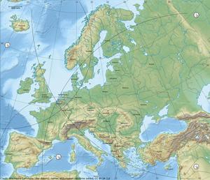
The Quest for Longitude
astroEDU educational activity (links to astroEDU website) Description: How to navigate at sea like an explorer?
License: CC-BY-4.0 Creative Commons Namensnennung 4.0 International (CC BY 4.0) Symbole
Schlagworte
Clocks
, Geography
, Coordinates
, Celestial navigation
, James Cook
, Exploration
Altersgruppen:
14-16
, 16-19
Bildungsniveau:
Middle School
, Secondary
Lernbereiche:
Discussion Groups
, Modelling
, Structured-inquiry learning
Kosten:
Low Cost
Dauer:
2 hours
Gruppengröße:
Group
Fähigkeiten:
Analysing and interpreting data
, Asking questions
, Communicating information
, Developing and using models
, Planning and carrying out investigations
, Using mathematics and computational thinking
Where on Earth am I?
astroEDU educational activity (links to astroEDU website) Description: How do satellite-based positioning and GPS navigation work?
License: CC-BY-4.0 Creative Commons Namensnennung 4.0 International (CC BY 4.0) Symbole
Schlagworte
Clocks
, Geography
, Maps
, GPS
, Countries
, Speed of light
, Galileo
Altersgruppen:
14-16
Bildungsniveau:
Middle School
Lernbereiche:
Guided-discovery learning
, Problem-solving
Kosten:
Low Cost
Dauer:
1 hour 30 mins
Gruppengröße:
Group
Fähigkeiten:
Analysing and interpreting data
, Asking questions
, Communicating information
, Constructing explanations
, Developing and using models
, Using mathematics and computational thinking
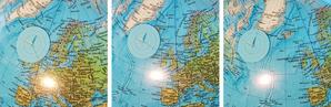
Navigate like a Viking – Use the Sun, not your phone!
astroEDU educational activity (links to astroEDU website) Description: Learn how the Vikings used the sky to navigate at sea with a hands-on activity!
License: CC-BY-4.0 Creative Commons Namensnennung 4.0 International (CC BY 4.0) Symbole
Schlagworte
History
, Geography
, Maps
, Coordinates
, Celestial navigation
Altersgruppen:
12-14
, 14-16
Bildungsniveau:
Middle School
Lernbereiche:
Discussion Groups
, Modelling
, Structured-inquiry learning
Kosten:
Medium Cost
Dauer:
1 hour 30 mins
Gruppengröße:
Group
Fähigkeiten:
Analysing and interpreting data
, Asking questions
, Communicating information
, Developing and using models
, Planning and carrying out investigations
, Using mathematics and computational thinking

