This page describes an image Karte des Sternbilds Indianer
Datei runterladen ( Bild 153.56 kB)
PDF Datei runterladen (PDF file 99.28 kB)
Untertitel Diagramm:
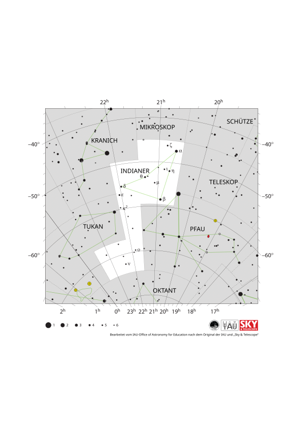
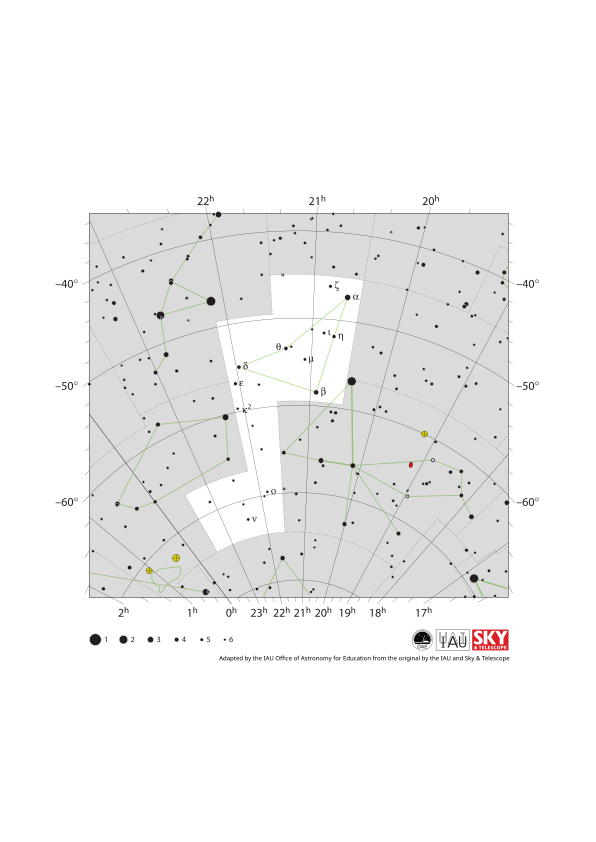
Das Sternbild Indianer (lateinisch Indus) mit seinen hellen Sternen und den umliegenden Sternbildern. Der Indianer ist umgeben von (im Uhrzeigersinn von oben beginnend): Mikroskop, Schütze, Teleskop, Pfau, Oktant, Tukan und Kranich.
Der Indianer liegt in der Nähe des südlichen Himmelspols, sodass das gesamte Sternbild zu einem Zeitpunkt des Jahres auf der gesamten südlichen Hemisphäre sichtbar ist. Das gesamte Sternbild ist auch auf einem schmalen Streifen der nördlichen Hemisphäre in der Nähe des Äquators zu sehen, während in den übrigen nördlichen Äquatorregionen zumindest Teile des Sternbilds sichtbar sind. Der Indianer ist in den gemäßigten und antarktischen Regionen der südlichen Hemisphäre zirkumpolar. Der indianer lässt sich am besten abends im Herbst der nördlichen Hemisphäre und im Frühling der südlichen Hemisphäre beobachten.
Die y-Achse dieses Diagramms zeigt die Deklination in Grad, wobei Norden oben liegt, und die x-Achse zeigt die Rektaszension in Stunden mit Osten nach links. Die Größe der hier dargestellten Sterne bezieht sich auf deren scheinbare Helligkeit, ein Maß für die ankommende Strahlungsintensität. Die größeren Punkte repräsentieren hellere Sterne. Die griechischen Buchstaben kennzeichnen die hellsten Sterne des Sternbilds. Diese sind nach Helligkeit geordnet, wobei der hellste Stern mit Alpha bezeichnet wird, der zweithellste mit Beta usw. – wobei diese Reihenfolge nicht immer exakt eingehalten wird. Die gepunkteten Grenzlinien markieren die offiziellen Sternbildgrenzen der IAU, und die durchgezogenen grünen Linien zeigen eine der üblichen Formen, um die Figuren der Sternbilder darzustellen. Weder die Sternbildgrenzen noch die Verbindungslinien zwischen den Sternen sind am realen Himmel zu sehen.
Quelle Diagramm: Bearbeitet vom IAU-Office of Astronomy for Education nach dem Original der IAU und „Sky & Telescope“. Link zur Quelle
Diagramm Übersetzungsstatus: Noch nicht bestätigt von einem Rezensenten
Diagramm-Übersetzer: Simon Kraus
Diagramm-Lizenz: Creative Commons Namensnennung 4.0 International (CC BY 4.0) Creative Commons Namensnennung 4.0 International (CC BY 4.0) Symbole
Ähnliche Glossarbegriffe:
Deklination
, Himmelskoordinaten
, Rektaszension (RA)
, Scheinbare Helligkeit
, Sternbild
, Zirkumpolarsterne
Kategorien:
Astronomie mit bloßem Auge
Möchtest du deine eigene Übersetzung oder Version dieses Diagrammes erstellen? Dann downloade die SVG
Version dieses Diagrammes auf Englisch (460.35 kB). Du kannst diese Version mit Programmen wie Inkscape (kostenlos) oder Adobe Illustrator (kostenpflichtig) bearbeiten. Bitte verweise dennoch auf den originalen Autor.
Du kannst Deine eigene Version oder Übersetzung dieses Diagrammes erstellen, indem du einer textlosen Version dieses Diagrammes eigenen Text zufügst.
Downloade einfach eine dieser Dateien:
Download Text-Free File ( Bild 104.89 kB)
Download Text-Free PDF File (PDF file 162.44 kB)
Auf anderen Sprachen
Englisch: Indus Constellation MapItalienisch: Mappa della Costellazione dell'Indiano
Traditionelles Chinesisch: 印第安座星圖
Vereinfachtes Chinesisch: 印第安座星图
The diagram captions presented on the OAE website were written, translated and reviewed by a collective effort from the OAE, the OAE Centers and Nodes, the OAE National Astronomy Education Coordinators (NAECs) and other volunteers. You can find a full list of credits for our translation project here. All media file captions are released under a Creative Commons CC BY-4.0 license and should be credited to "IAU OAE". The media files themselves may have different licenses (see above) and should be credited as listed above under "credit".
Sollte dir ein Fehler in diesem Diagramm oder seiner Unterschrift auffallen, bitte kontaktiere uns.

