Glossar-Begriff: Himmelskoordinaten
Beschreibung: Von der Erde aus nehmen wir Himmelsobjekte so wahr, als befänden sie sich auf einer Kugel, die üblicherweise Himmelskugel genannt wird. Wir können jede Position auf dieser Sphäre mit zwei Zahlen beschreiben. Jede Methode, um zwei solcher Zahlen einer Position am Himmel zuzuordnen, wird als Himmelskoordinatensystem bezeichnet. Die zwei Zahlen werden als die (Himmels-)Koordinaten des Objekts bezeichnet.
Auf der Erdoberfläche verwenden wir für den gleichen Zweck die geografische Breite und Länge. Daraus leitet sich auch eine Methode zur Definition von Himmelskoordinaten ab: Die Punkte am Himmel, die sich direkt über dem Äquator der Erde befinden, bilden den Himmelsäquator. Einem Punkt, der sich direkt über einem bestimmten Ort auf der Erdkugel befindet, werden Zahlen zugeordnet, die der geografischen Breite/Länge des Punkts auf der Erdoberfläche entsprechen.
Astronomen verwenden verschiedene Arten von Koordinatensystemen. Darunter ist auch ein System, das die tägliche Rotation der Erde berücksichtigt, sodass die Koordinaten universell sind und überall auf der Erde verwendet werden können. Dadurch wird auch sichergestellt, dass sich die Koordinaten z. B. eines Sterns über Zeiträume von Tagen, Monaten oder Jahren nicht wesentlich ändern.
Ähnliche Begriffe:
Dieser Begriff in anderen Sprachen
Begriffs- und Definitionsstatus Die Originaldefinition dieses Begriffes auf Englisch wurden von einem forschenden Astronom und einer Lehrkraft bestätigt Die Übersetzung dieses Begriffs und seiner Definition warten auf Prüfung und Bestätigung
The OAE Multilingual Glossary is a project of the IAU Office of Astronomy for Education (OAE) in collaboration with the IAU Office of Astronomy Outreach (OAO). The terms and definitions were chosen, written and reviewed by a collective effort from the OAE, the OAE Centers and Nodes, the OAE National Astronomy Education Coordinators (NAECs) and other volunteers. You can find a full list of credits here. All glossary terms and their definitions are released under a Creative Commons CC BY-4.0 license and should be credited to "IAU OAE".
Wenn dir ein inhaltlicher oder Übersetzungsfehler in diesem Glossarbegriff oder dieser Definition auffallen, bitte kontaktiere uns.
Auf anderen Sprachen
- Arabisch: الإحداثيات السماوية
- Englisch: Celestial Coordinates
- Spanisch: Coordenadas celestes
- Französisch: Coordonnées célestes
- Italienisch: Coordinate celesti
- Japanisch: 天球座標系 (externer Link)
- Koreanisch: 천구좌표
- Brasilianisches Portugiesisch: Coordenadas celestes
- Vereinfachtes Chinesisch: 天球坐标
- Traditionelles Chinesisch: 天球坐標
Ähnliche Diagramme
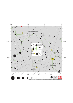
Crux Constellation Map
Unterschrift: The constellation Crux (commonly known as the Southern Cross or Crux Australis) showing its bright stars and surrounding constellations. The Southern Cross is surrounding by (going clockwise from the top) Centaurus, Carina and Musca. The brightest star is alpha Crucis which appears at the bottom of the constellation's famous kite shape. The Southern Cross is visible from southern and equatorial regions of the world. In more southerly parts of the world it is circumpolar so is always above the horizon. In other parts of the southern hemisphere and in equatorial regions it is most visible in the evenings in the southern hemisphere autumn.
The yellow circles show the locations of two open clusters, NGC 4755 (known as the Jewel Box) and NGC 4609.
The line joining gamma and alpha Crucis (the third and first brightest stars in the Southern Cross) points in the approximate direction of the South Celestial Pole. This has led to the Southern Cross playing an important role in celestial navigation, allowing navigators from different astronomical traditions to find their bearings.
The y-axis of this diagram is in degrees of declination with north as up and the x-axis is in hours of right ascension with east to the left. The sizes of the stars marked here relate to the star's apparent magnitude, a measure of its apparent brightness. The larger dots represent brighter stars. The Greek letters mark the brightest stars in the constellation. These are ranked by brightness with the brightest star being labeled alpha, the second brightest beta, etc., although this ordering is not always followed exactly. The dotted boundary lines mark the IAU's boundaries of the constellations and the solid green lines mark one of the common forms used to represent the figures of the constellations. Neither the constellation boundaries, nor the lines joining the stars appear on the sky.
Bild: Adapted by the IAU Office of Astronomy for Education from the original by IAU/Sky & Telescope.
License: CC-BY-4.0 Creative Commons Namensnennung 4.0 International (CC BY 4.0) Symbole

Orion-Sternkarte
Unterschrift: Das Sternbild Orion mit seinen hellen Sternen und den umliegenden Sternbildern. Im Uhrzeigersinn von Oben ist Orion umgeben von dem Stier, Eridanus, dem Hasen, dem Einhorn und Zwilling. Die hellsten Sterne des Orion, Betelgeuze und Rigel, befinden sich am nördlichen (in dieser Abbildung oberen) bzw. südlichen (unteren) Ende des Sternbilds, mit dem berühmten Dreisternegürtel in der Mitte.
Orion erstreckt sich über den Himmelsäquator und ist daher im Laufe des Jahres irgendwann von der gesamten Erde aus sichtbar. In den arktischen oder antarktischen Regionen der Welt sind einige Teile des Sternbilds möglicherweise nicht sichtbar. Orion ist am besten Abends im Winter auf der Nordhalbkugel und im Sommer auf der Südhalbkugel zu sehen. Die blaue Linie über Orion markiert die Ekliptik, also den Weg, den die Sonne im Laufe eines Jahres über den Himmel zu gehen scheint. Die Sonne läuft nie durch den Orion, aber man kann gelegentlich die anderen Planeten des Sonnensystems und den Mond im Orion finden.
Direkt südlich des Gürtels des Orion liegen die beiden Messier-Objekte M42 (der Orionnebel) und M43, die durch grüne Quadrate gekennzeichnet sind. Diese Nebel sind zusammen mit M78 (hier das grüne Quadrat links vom Gürtel) Teil des riesigen Orion-Molekülwolkenkomplexes. Dieser erstreckt sich über den größten Teil des Sternbilds und umfasst Regionen, in denen diese Molekülwolken kollabieren und junge Sterne bilden.
Die y-Achse dieses Diagramms ist in Deklinationsgraden mit Norden nach oben und die x-Achse in Rektaszensionsstunden mit Osten nach links angegeben. Die Größe der hier markierten Sterne bezieht sich auf die scheinbare Helligkeit des Sterns. Je größer die Punkte, desto heller scheinen die Sterne die sie darstellen. Die griechischen Buchstaben kennzeichnen die hellsten Sterne des Sternbildes. Sie sind nach Helligkeit geordnet, wobei der hellste Stern mit Alpha, der zweithellste mit Beta usw. bezeichnet wird, obwohl diese Reihenfolge nicht immer genau eingehalten wird. Der Kreis um Betelgeuse zeigt an, dass es sich um einen veränderlichen Stern handelt. Die gepunkteten Begrenzungslinien markieren die IAU-Grenzen der Sternbilder und die durchgezogenen grünen Linien markieren eine der üblichen Formen, die zur Darstellung der Sternbilder verwendet werden. Weder die Sternbildgrenzen noch die Linie, die die Ekliptik markiert, noch die Linien, die die Sterne miteinander verbinden, sind so am Himmel sichtbar.
Bild: Angepasst vom IAU Office of Astronomy for Education nach dem Original von IAU/Sky & Telescope
License: CC-BY-4.0 Creative Commons Namensnennung 4.0 International (CC BY 4.0) Symbole
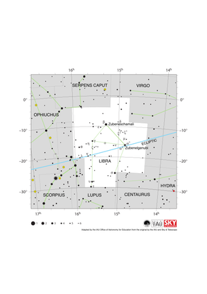
Libra Constellation Map
Unterschrift: The constellation Libra along with its bright stars and surrounding constellations. Libra is surrounded by (going clockwise from the top) Serpens Caput, Virgo, Hydra, Centaurus, Lupus, Scorpius and Ophiuchus. Libra lies on the ecliptic (shown here as a blue line), this is the path the Sun appears to take across the sky over the course of a year. The Sun is in Libra from late October to late November. The other planets of the Solar System can often be found in Libra.
Libra lies just south of the celestial equator and is thus visible at some time in all but the most arctic regions. Libra is most visible in the evenings in the northern hemisphere late spring/early summer and southern hemisphere late autumn/early winter.
The y-axis of this diagram is in degrees of declination with north as up and the x-axis is in hours of right ascension with east to the left. The sizes of the stars marked here relate to the star's apparent magnitude, a measure of its apparent brightness. The larger dots represent brighter stars. The Greek letters mark the brightest stars in the constellation. These are ranked by brightness with the brightest star being labeled alpha, the second brightest beta, etc., although this ordering is not always followed exactly. The dotted boundary lines mark the IAU's boundaries of the constellations and the solid green lines mark one of the common forms used to represent the figures of the constellations. Neither the constellation boundaries, nor the line marking the ecliptic, nor the lines joining the stars appear on the sky.
Bild: Adapted by the IAU Office of Astronomy for Education from the original by IAU/Sky & Telescope
License: CC-BY-4.0 Creative Commons Namensnennung 4.0 International (CC BY 4.0) Symbole
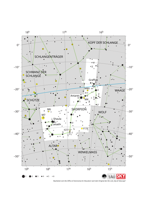
Karte des Sternbilds Skorpion
Unterschrift: Das Sternbild Skorpion (lateinisch Scorpio) mit seinen hellen Sternen und den umliegenden Sternbildern. Der Skorpion ist umgeben von (im Uhrzeigersinn von oben beginnend) dem Schlangenträger, dem Kopf der Schlange, der Waage, dem Wolf, dem Winkelmaß, dem Altar, der südlichen Krone und dem Schützen. Der hellste Stern des Skorpions, Antares, befindet sich im Herzen des Sternbilds, während sich der berühmte Schwanz des Skorpions nach Südosten (unten links) erstreckt. Der Skorpion liegt auf der Ekliptik (hier als blaue Linie dargestellt); dies ist die Bahn, die die Sonne im Laufe eines Jahres scheinbar am Himmel zurücklegt. Die Sonne verbringt nur eine kurze Zeit Ende November im Sternbild Skorpion. Die Planeten des Sonnensystems sind regelmäßig im Skorpion zu finden.
Der Skorpion liegt südlich des Himmelsäquators. Das gesamte Sternbild ist von den arktischen Regionen der Erde aus nicht sichtbar. Für Beobachter in den nördlichen Teilen Asiens, Europas und Nordamerikas sind Teile des Skorpions verdeckt. Der Skorpion ist am besten abends im Sommer der nördlichen Hemisphäre und im Winter der südlichen Hemisphäre zu sehen.
Die gelben Kreise markieren die Positionen der offenen Sternhaufen M6, M7 und NGC 6231, während die gelben Kreise mit darübergelegten Pluszeichen die Kugelsternhaufen M4 und M80 kennzeichnen.
Die y-Achse dieses Diagramms zeigt die Deklination in Grad, wobei Norden oben liegt, und die x-Achse zeigt die Rektaszension in Stunden mit Osten nach links. Die Größe der hier dargestellten Sterne bezieht sich auf deren scheinbare Helligkeit, ein Maß für die ankommende Strahlungsintensität. Die größeren Punkte repräsentieren hellere Sterne. Die griechischen Buchstaben kennzeichnen die hellsten Sterne des Sternbilds. Diese sind nach Helligkeit geordnet, wobei der hellste Stern mit Alpha bezeichnet wird, der zweithellste mit Beta usw. – wobei diese Reihenfolge nicht immer exakt eingehalten wird. Die gepunkteten Grenzlinien markieren die offiziellen Sternbildgrenzen der IAU, und die durchgezogenen grünen Linien zeigen eine der üblichen Formen, um die Figuren der Sternbilder darzustellen. Weder die Sternbildgrenzen noch die Verbindungslinien zwischen den Sternen sind am realen Himmel zu sehen.
Bild: Bearbeitet vom IAU-Office of Astronomy for Education nach dem Original der IAU und „Sky & Telescope“
License: CC-BY-4.0 Creative Commons Namensnennung 4.0 International (CC BY 4.0) Symbole
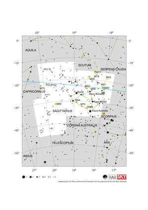
Sagittarius Constellation Map
Unterschrift: The constellation Sagittarius along with its bright stars and surrounding constellations. Sagittarius is surrounded by (going clockwise from the top) Aquila, Scutum, Serpens Cauda, Ophiuchus, Scorpius, Corona Australis, Telescopium, Microscopium and Capricornus. The brighter stars in Sagittarius form a distinctive teapot shape. Sagittarius lies on the ecliptic (shown here as a blue line), this is the path the Sun appears to take across the sky over the course of a year. The Sun is in Sagittarius from mid December to mid January. The other planets of the Solar System can often be found in Sagittarius.
Sagittarius lies south of the celestial equator. The famous teapot asterism is visible for all but the most arctic regions of the world but the most southerly parts of the constellation are not visible in northern parts of Asia, Europe and North America. Sagittarius is most visible in the evenings in the northern hemisphere summer and southern hemisphere winter.
The supermassive black hole Sagittarius A* which lies at the center of our Milky Way Galaxy is sits on the western (here right-hand) edge of Sagittarius. Due to it covering an area at the center of our Galaxy, Sagittarius is home to many star clusters including open clusters (marked here with yellow circles) and globular clusters (marked here with yellow circles with + signs superimposed on them). Three nebulae are also marked here with green squares.
The y-axis of this diagram is in degrees of declination with north as up and the x-axis is in hours of right ascension with east to the left. The sizes of the stars marked here relate to the star's apparent magnitude, a measure of its apparent brightness. The larger dots represent brighter stars. The Greek letters mark the brightest stars in the constellation. These are ranked by brightness with the brightest star being labeled alpha, the second brightest beta, etc., although this ordering is not always followed exactly. The dotted boundary lines mark the IAU's boundaries of the constellations and the solid green lines mark one of the common forms used to represent the figures of the constellations. Neither the constellation boundaries, nor the line marking the ecliptic, nor the lines joining the stars appear on the sky.
Bild: Adapted by the IAU Office of Astronomy for Education from the original by IAU/Sky & Telescope
License: CC-BY-4.0 Creative Commons Namensnennung 4.0 International (CC BY 4.0) Symbole
Ähnliche Aktivitäten

Navigation in the Ancient Mediterranean and Beyond
astroEDU educational activity (links to astroEDU website) Description: Learn the ancient skill of Celestial Navigation
License: CC-BY-4.0 Creative Commons Namensnennung 4.0 International (CC BY 4.0) Symbole
Schlagworte
History
, Geography
, Celestial navigation
Altersgruppen:
14-16
, 16-19
Bildungsniveau:
Middle School
, Secondary
Lernbereiche:
Discussion Groups
, Modelling
, Structured-inquiry learning
Kosten:
Low Cost
Dauer:
1 hour 30 mins
Gruppengröße:
Group
Fähigkeiten:
Analysing and interpreting data
, Asking questions
, Communicating information
, Developing and using models
, Planning and carrying out investigations
, Using mathematics and computational thinking

