词条 赤道
描述: 赤道是一条环绕地球的假想线,与南北两极的距离相等,且垂直于地球自转轴。赤道是地球表面距离自转轴最远的一条线。在两极,自转轴与地表相交。在地球表面的经纬度坐标系中,赤道的纬度定义为为零度。赤道将地球分为南北半球。位于北半球的地点,其纬度为正;而位于南半球的地点,其纬度为负。
相关词条
用其他语言查看该词条
词条和定义状态: 该术语的英文原始定义已通过天文研究人员和教师的审核 该术语及其定义的译文仍待审核
OAE多语言词汇表是由国际天文学联合会(IAU) 天文教育办公室(OAE) 和 国际天文学联合会(IAU) 天文推广办公室(OAO)合作的项目。. 术语和定义由 OAE中心, OAE 国家天文教育协调员(NAECs) 以及其他志愿者共同选择、撰写和审阅。您可以在 找到完整的致谢列表。所有词汇表术语及其定义均根据 Creative Commons CC BY-4.0许可证发布 且版权归属于 “IAU OAE”。
如果您发现此词汇术语或定义中的事实或翻译错误, 请向 发邮件 联系.
相关媒体

The Prime Meridian
图注: The prime meridian is defined as zero degrees longitude and runs from the North Pole through Greenwich in London to the South Pole. It is represented as a bright red line on this schematic Earth map. The horizontal line corresponds to the equator, while the antimeridian itself forms the outer edges at 180 degrees to the west and east.
来源: Wikicommons user Kmf164
来源链接
License: PD 公共领域 图标
相关图表

Latitude and Longitude
图注: Two views of the Earth, one viewing the Northern Hemisphere, one viewing the Southern Hemisphere. The Earth rotates around its axis, an imaginary line that runs through the Earth from the North Pole to the South Pole. The Equator is an imaginary line that is the same distant from both the North Pole and the South Pole.
The positions of two cities, Rome in the Northern Hemisphere and Sydney in the Southern Hemisphere are marked here with red dots. Arrows indicate the two spherical coordinates latitude and longitude.
Latitude marks the position north or south of the equator. Here we can see Rome has the letter N in its latitude as it is in the Northern Hemisphere and Sydney has the letter S in its latitude as it is in the Southern Hemisphere. Latitude can vary from 90° N at the North Pole to 0° at the Equator to 90° S at the South Pole.
Longitude measures the position around the equator. While the choice of the zero point for latitude as the equator seems obvious, the choice of the zero point for longitude is more subjective. By convention the zero point in longitude is the prime meridian which passes through the Royal Greenwich Observatory in the UK. This is marked here as a solid line originating at the North Pole. Longitude is measured in degrees east or west of the prime meridian. As both Rome and Sydney lie to the east of Greenwich, they have the letter E as part of their longitude. Moving west to east, longitude varies from 180° W on the other side of the world from the prime meridian to 0° on the prime meridian before reaching 180° E again on the other side of world from the prime meridian.
This diagram shows the Earth at the December solstice. Two views are presented, one viewing the Northern Hemisphere and one viewing the Southern Hemisphere about nine hours later. The shaded region shows the night side of the Earth, with the day side being lighter. As it is the December solstice, the Sun appears overhead at the Tropic of Capricorn. This is a line of constant latitude at 23°26′09.3″ S. Six months later, at the June solstice, the Sun will appear to be overhead at the Tropic of Cancer at 23°26′09.3″ N. As the Sun appears over the Tropic of Capricorn more of the Southern Hemisphere is illuminated than the Northern Hemisphere. Indeed below the Antarctic Circle (the Polar Circle around the South Pole) the Sun does not set at this time of year leading to a Polar Day. Conversely, north of the Arctic Circle (the Polar Circle around the North Pole) the Sun does not rise at this time of year, leading to a Polar Night.
来源: Maria Cristina Fortuna/IAU OAE

Seasons
图注: This diagram shows the Earth at the June solstice which is known as the summer solstice in the Northern Hemisphere and the winter solstice in the Southern Hemisphere. The Earth’s axis of rotation is tilted from the axis of the Earth’s orbit around the Sun by 23.4°. Here we see light from the sun represented as parallel lines, in the diagram the Sun would lie far off the right-hand edge. Five lines are marked with angles. These lines hit the Earth at special latitudes. From top to bottom these lines hit the Earth at the North Pole, the Tropic of Cancer, the Equator, the Tropic of Capricorn and the Antarctic Circle. The lines are shown hitting the Earth at the longitude where it is currently noon. For the last four lines, the angles marked show the angle above the horizon (the altitude) which the Sun appears in the sky at at local noon.
At the June solstice, the Sun will appear directly overhead at local noon on every point on the Tropic of Capricorn. By contrast the Sun reaches a maximum altitude of 0° at local noon on every point in the Antarctic Circle. This means the Sun never rises and every point south of the Antarctic Circle experiences a long Polar Night. By contrast the Sun never sets on this day north of the Arctic Circle and the regions here experience a Polar Day. The at the North Pole the Sun will remain at a constant altitude all day. This altitude will be the angle 180°-156.6° (23.4°).
The altitude the Sun appears at is important as it defines how spread out the Sun’s rays are on the Earth’s surface. Look at the thick, faint parallel lines in the background. Notice how at the Tropic of Cancer the area the lines intersect with the Earth’s surface perpendicularly and the line only covers a small part of the Earth’s surface. Now look at a line near the Tropic of Capricorn and see that this intersects with the Earth at a grazing angle and the line is spread out, covering a much wider area of the Earth’s surface. This means that a given amount of light from the Sun that hits the Tropic of Cancer is more concentrated and the same amount of light hitting the Tropic of Capricorn would be more spread out. This leads to more energy per unit area from the Sun hitting the Tropic of Cancer and less energy per unit area hitting the Tropic of Capricorn. This means it will be warmer at the Tropic of Cancer than at the Tropic of Capricorn. It is thus summer at the Tropic of Cancer and winter at the Tropic of Capricorn.
Six months later this situation will be reversed and it will be summer at the Tropic of Capricorn and winter at the Tropic of Cancer.
来源: Maria Cristina Fortuna/IAU OAE
相关活动
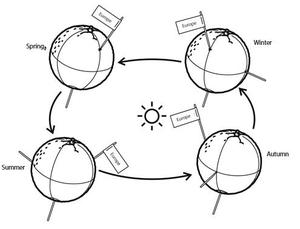
Seasons Around the World
astroEDU educational activity (links to astroEDU website) Description: Demonstrate the seasons on Earth using a model.
License: CC-BY-4.0 知识共享许可协议 署名 4.0 国际 (CC BY 4.0) 图标
标签:
Hands-on
, Model
年龄段:
6-8
, 8-10
, 10-12
受教育等级:
初中
, Primary
学习领域:
建模
, 结构化探究式学习
费用:
中等成本
时间跨度:
45 分钟
组别大小:
小组
技能:
分析和解读数据
, 提出问题
, 构建解释
, 开发和使用模型
, 规划并开展调查
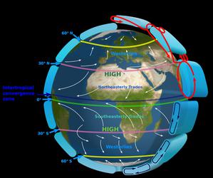
The Intertropical Convergence Zone
astroEDU educational activity (links to astroEDU website) Description: The air circulation system: how are winds created?
License: CC-BY-4.0 知识共享许可协议 署名 4.0 国际 (CC BY 4.0) 图标
标签:
Climate
, Updraft
, Convection
, Winds
年龄段:
12-14
, 14-16
受教育等级:
初中
学习领域:
讨论小组
, 建模
, 结构化探究式学习
费用:
中等成本
时间跨度:
1 小时
组别大小:
小组
技能:
传达信息
, 构建解释
, 开发和使用模型
, 从证据中进行论证
, 规划并开展调查
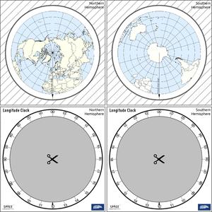
The Quest for Longitude
astroEDU educational activity (links to astroEDU website) Description: How to navigate at sea like an explorer?
License: CC-BY-4.0 知识共享许可协议 署名 4.0 国际 (CC BY 4.0) 图标
标签:
Clocks
, Geography
, Coordinates
, Celestial navigation
, James Cook
, Exploration
年龄段:
14-16
, 16-19
受教育等级:
初中
, 中学
学习领域:
讨论小组
, 建模
, 结构化探究式学习
费用:
低成本
时间跨度:
2 小时
组别大小:
小组
技能:
分析和解读数据
, 提出问题
, 传达信息
, 开发和使用模型
, 规划并开展调查
, 使用数学和计算思维

Navigating with the Kamal – Northern Hemisphere
astroEDU educational activity (links to astroEDU website) Description: How did Arabian sailors navigate at sea?
License: CC-BY-4.0 知识共享许可协议 署名 4.0 国际 (CC BY 4.0) 图标
标签:
History
, Geography
, Coordinates
, Celestial navigation
, Arabia
, Kamal
年龄段:
14-16
, 16-19
受教育等级:
初中
, 中学
学习领域:
建模
, 结构化探究式学习
费用:
低成本
时间跨度:
1 小时 30 分钟
组别大小:
小组
技能:
分析和解读数据
, 提出问题
, 传达信息
, 开发和使用模型
, 规划并开展调查
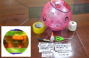
Discover Earth's climate with a balloon
astroEDU educational activity (links to astroEDU website) Description: Discover the secrets of Earth's climate zones with a hands-on experience
License: CC-BY-4.0 知识共享许可协议 署名 4.0 国际 (CC BY 4.0) 图标
年龄段:
8-10
, 10-12
受教育等级:
初中
, Primary
学习领域:
趣味活动
, 引导式发现学习
, 建模
, 以观察为主
, 项目式学习
, 结构化探究式学习
费用:
低成本
时间跨度:
45 分钟
组别大小:
小组
技能:
提出问题
, 构建解释
, 开发和使用模型

