Glossary term: Ecuador
Description: El ecuador es una línea imaginaria que rodea la Tierra, equidistante de los polos norte y sur y perpendicular al eje de rotación de la Tierra. El ecuador marca la línea de la superficie terrestre más alejada del eje de rotación. En los polos, el eje de rotación se cruza con la superficie. En el sistema de coordenadas de latitud y longitud de la superficie terrestre, el ecuador se define como un punto con cero grados de latitud. El ecuador divide la Tierra en un hemisferio norte y un hemisferio sur. Los lugares del hemisferio norte tienen latitud positiva; los lugares del hemisferio sur tienen latitud negativa.
Related Terms:
- Eje
- Latitud
- Longitud
- Círculo Polar Ártico
- Día
- El eje de rotación de la Tierra
- Noche
- Trópico
- Polo norte
- Polo Sur
See this term in other languages
Term and definition status: The original definition of this term in English have been approved by a research astronomer and a teacher The translation of this term and its definition is still awaiting approval
The OAE Multilingual Glossary is a project of the IAU Office of Astronomy for Education (OAE) in collaboration with the IAU Office of Astronomy Outreach (OAO). The terms and definitions were chosen, written and reviewed by a collective effort from the OAE, the OAE Centers and Nodes, the OAE National Astronomy Education Coordinators (NAECs) and other volunteers. You can find a full list of credits here. All glossary terms and their definitions are released under a Creative Commons CC BY-4.0 license and should be credited to "IAU OAE".
If you notice a factual or translation error in this glossary term or definition then please get in touch.
Related Media

The Prime Meridian
Caption: The prime meridian is defined as zero degrees longitude and runs from the North Pole through Greenwich in London to the South Pole. It is represented as a bright red line on this schematic Earth map. The horizontal line corresponds to the equator, while the antimeridian itself forms the outer edges at 180 degrees to the west and east.
Credit: Wikicommons user Kmf164
credit link
License: PD Public Domain icons
Related Diagrams
Latitud y longitud
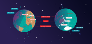
Caption: Dos vistas de la Tierra, una del hemisferio norte y otra del hemisferio sur. La Tierra rota alrededor de su eje, una línea imaginaria que la atraviesa desde el polo norte hasta el polo sur. El ecuador es una línea imaginaria que está a la misma distancia del polo norte que del polo sur.
Las posiciones de dos ciudades, Roma en el hemisferio norte y Sídney en el hemisferio sur, están marcadas aquí con puntos rojos. Las flechas indican las dos coordenadas esféricas: latitud y longitud.
La latitud marca la posición al norte o al sur del ecuador. Aquí podemos ver que Roma tiene la letra N en su latitud, puesto que se encuentra en el hemisferio norte, y Sídney tiene la letra S en su latitud, ya que se encuentra en el hemisferio sur. La latitud puede variar desde los 90° N en el polo norte, los 0° en el ecuador y hasta los 90° S en el polo sur.
La longitud mide la posición en torno al ecuador. Mientras que la elección del punto cero para la latitud en el ecuador parece obvia, la elección del punto cero para la longitud es más subjetiva. Por convenio, el punto cero en longitud es el meridiano principal que pasa por el Observatorio Real de Greenwich en el Reino Unido. Aquí se marca como una línea continua que parte del polo norte. La longitud se mide en grados al este o al oeste del meridiano de referencia. Dado que tanto Roma como Sídney se encuentran al este de Greenwich, tienen la letra E como parte de su longitud. De oeste a este, la longitud varía desde los 180° O, al otro lado del mundo respecto al meridiano de referencia, los 0° en ese meridiano, hasta alcanzar de nuevo los 180° E al otro lado del mundo respecto al meridiano de referencia.
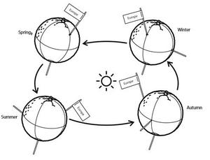
Este diagrama muestra la Tierra en el solsticio de diciembre. Se presentan dos vistas, una del hemisferio norte y otra del hemisferio sur, unas nueve horas más tarde. La región sombreada muestra el lado nocturno de la Tierra, mientras que el lado diurno es más claro. Al ser el solsticio de diciembre, el Sol se encuentra en su punto más alto sobre el Trópico de Capricornio. Esta es una línea de latitud constante a 23°26′09,3″ S. Seis meses más tarde, en el solsticio de junio, el Sol parecerá estar en su punto más alto sobre el Trópico de Cáncer, a 23°26′09,3″ N. Cuando el Sol se eleva sobre el Trópico de Capricornio, se ilumina una mayor parte del hemisferio sur que del hemisferio norte. De hecho, por debajo del círculo antártico (el círculo polar alrededor del polo sur), el Sol no se pone en esta época del año, lo que da lugar a un día polar. Por el contrario, al norte del círculo ártico (el círculo polar alrededor del polo norte), el Sol no sale en esta época del año, lo que da lugar a una noche polar.
Credit: María Cristina Fortuna/IAU OAE
License: CC-BY-4.0 Creative Commons Reconocimiento 4.0 Internacional (CC BY 4.0) icons

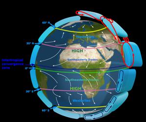
Seasons
Caption: This diagram shows the Earth at the June solstice which is known as the summer solstice in the Northern Hemisphere and the winter solstice in the Southern Hemisphere. The Earth’s axis of rotation is tilted from the axis of the Earth’s orbit around the Sun by 23.4°. Here we see light from the sun represented as parallel lines, in the diagram the Sun would lie far off the right-hand edge. Five lines are marked with angles. These lines hit the Earth at special latitudes. From top to bottom these lines hit the Earth at the North Pole, the Tropic of Cancer, the Equator, the Tropic of Capricorn and the Antarctic Circle. The lines are shown hitting the Earth at the longitude where it is currently noon. For the last four lines, the angles marked show the angle above the horizon (the altitude) which the Sun appears in the sky at at local noon.
At the June solstice, the Sun will appear directly overhead at local noon on every point on the Tropic of Capricorn. By contrast the Sun reaches a maximum altitude of 0° at local noon on every point in the Antarctic Circle. This means the Sun never rises and every point south of the Antarctic Circle experiences a long Polar Night. By contrast the Sun never sets on this day north of the Arctic Circle and the regions here experience a Polar Day. The at the North Pole the Sun will remain at a constant altitude all day. This altitude will be the angle 180°-156.6° (23.4°).
The altitude the Sun appears at is important as it defines how spread out the Sun’s rays are on the Earth’s surface. Look at the thick, faint parallel lines in the background. Notice how at the Tropic of Cancer the area the lines intersect with the Earth’s surface perpendicularly and the line only covers a small part of the Earth’s surface. Now look at a line near the Tropic of Capricorn and see that this intersects with the Earth at a grazing angle and the line is spread out, covering a much wider area of the Earth’s surface. This means that a given amount of light from the Sun that hits the Tropic of Cancer is more concentrated and the same amount of light hitting the Tropic of Capricorn would be more spread out. This leads to more energy per unit area from the Sun hitting the Tropic of Cancer and less energy per unit area hitting the Tropic of Capricorn. This means it will be warmer at the Tropic of Cancer than at the Tropic of Capricorn. It is thus summer at the Tropic of Cancer and winter at the Tropic of Capricorn.
Six months later this situation will be reversed and it will be summer at the Tropic of Capricorn and winter at the Tropic of Cancer.
Credit: Maria Cristina Fortuna/IAU OAE
License: CC-BY-4.0 Creative Commons Reconocimiento 4.0 Internacional (CC BY 4.0) icons
Related Activities
Seasons Around the World
astroEDU educational activity (links to astroEDU website) Description: Demonstrate the seasons on Earth using a model.
License: CC-BY-4.0 Creative Commons Reconocimiento 4.0 Internacional (CC BY 4.0) icons
Tags:
Hands-on
, Model
Age Ranges:
6-8
, 8-10
, 10-12
Education Level:
Middle School
, Primary
Areas of Learning:
Modelling
, Structured-inquiry learning
Costs:
Medium Cost
Duration:
45 mins
Group Size:
Group
Skills:
Analysing and interpreting data
, Asking questions
, Constructing explanations
, Developing and using models
, Planning and carrying out investigations
The Intertropical Convergence Zone
astroEDU educational activity (links to astroEDU website) Description: The air circulation system: how are winds created?
License: CC-BY-4.0 Creative Commons Reconocimiento 4.0 Internacional (CC BY 4.0) icons
Tags:
Climate
, Updraft
, Convection
, Winds
Age Ranges:
12-14
, 14-16
Education Level:
Middle School
Areas of Learning:
Discussion Groups
, Modelling
, Structured-inquiry learning
Costs:
Medium Cost
Duration:
1 hour
Group Size:
Group
Skills:
Communicating information
, Constructing explanations
, Developing and using models
, Engaging in argument from evidence
, Planning and carrying out investigations
The Quest for Longitude
astroEDU educational activity (links to astroEDU website) Description: How to navigate at sea like an explorer?
License: CC-BY-4.0 Creative Commons Reconocimiento 4.0 Internacional (CC BY 4.0) icons
Tags:
Clocks
, Geography
, Coordinates
, Celestial navigation
, James Cook
, Exploration
Age Ranges:
14-16
, 16-19
Education Level:
Middle School
, Secondary
Areas of Learning:
Discussion Groups
, Modelling
, Structured-inquiry learning
Costs:
Low Cost
Duration:
2 hours
Group Size:
Group
Skills:
Analysing and interpreting data
, Asking questions
, Communicating information
, Developing and using models
, Planning and carrying out investigations
, Using mathematics and computational thinking

Navigating with the Kamal – Northern Hemisphere
astroEDU educational activity (links to astroEDU website) Description: How did Arabian sailors navigate at sea?
License: CC-BY-4.0 Creative Commons Reconocimiento 4.0 Internacional (CC BY 4.0) icons
Tags:
History
, Geography
, Coordinates
, Celestial navigation
, Arabia
, Kamal
Age Ranges:
14-16
, 16-19
Education Level:
Middle School
, Secondary
Areas of Learning:
Modelling
, Structured-inquiry learning
Costs:
Low Cost
Duration:
1 hour 30 mins
Group Size:
Group
Skills:
Analysing and interpreting data
, Asking questions
, Communicating information
, Developing and using models
, Planning and carrying out investigations
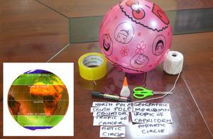
Discover Earth's climate with a balloon
astroEDU educational activity (links to astroEDU website) Description: Discover the secrets of Earth's climate zones with a hands-on experience
License: CC-BY-4.0 Creative Commons Reconocimiento 4.0 Internacional (CC BY 4.0) icons
Age Ranges:
8-10
, 10-12
Education Level:
Middle School
, Primary
Areas of Learning:
Fun activity
, Guided-discovery learning
, Modelling
, Observation based
, Project-based learning
, Structured-inquiry learning
Costs:
Low Cost
Duration:
45 mins
Group Size:
Group
Skills:
Asking questions
, Constructing explanations
, Developing and using models

