Terme du glossaire : Équateur
Description : L'équateur est une ligne imaginaire qui fait le tour de la Terre, à égale distance des pôles Nord et Sud et perpendiculaire à l'axe de rotation de la Terre. L'équateur marque la ligne de la surface de la Terre la plus éloignée de l'axe de rotation. Aux pôles, l'axe de rotation croise la surface. Dans le système de coordonnées de latitude et de longitude à la surface de la Terre, l'équateur est défini comme ayant une latitude de zéro degré. L'équateur divise la Terre en un hémisphère nord et un hémisphère sud. Les endroits de l'hémisphère nord ont une latitude positive ; les endroits de l'hémisphère sud ont une latitude négative.
Termes associés :
Voir ce terme dans d'autres langues
Statut du terme et de sa définition : La définition initiale de ce terme en anglais a été aprouvée par un·e spécialiste de la recherche en astronomie et un·e spécialiste de l’éducation La traduction de ce terme et de sa définition n'ont pas encore été aprouvées
Le glossaire multilangue de l'OAE est un projet du Bureau de l'IAU de l'Astronomie pour l'Education (OAE) en collaboration avec le Bureau de l'IAU de diffusion de l'Astronomie (OAO). Les termes et définitions ont été choisis, écrits et relues grâce à un effort collectif de l'OAE, les Centres et les Noeuds de l'OAE, les Coordinateurs Nationaux de l'Astronomie pour l'Education de l'OAE(NAECs) et d'autres volontaires. La liste complète des crédits pour ce projet est disponible ici . Tous les termes du glossaire et leur définition sont déposés sous licence Creative Commons CC BY-4.0 et doivent être créditées au nom de "IAU OAE".
Si vous constatez une erreur dans ce terme ou sa définition, veuillez nous contacter .
Media associé

The Prime Meridian
Légende : The prime meridian is defined as zero degrees longitude and runs from the North Pole through Greenwich in London to the South Pole. It is represented as a bright red line on this schematic Earth map. The horizontal line corresponds to the equator, while the antimeridian itself forms the outer edges at 180 degrees to the west and east.
Crédit : Wikicommons user Kmf164
Lien vers les crédits
License: PD Domaine Public Icônes
Diagrammes associés

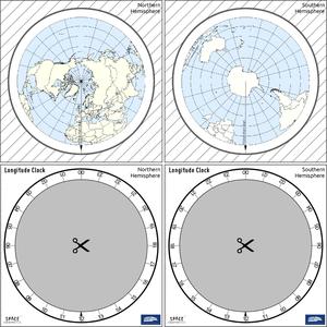
Latitude and Longitude
Légende : Two views of the Earth, one viewing the Northern Hemisphere, one viewing the Southern Hemisphere. The Earth rotates around its axis, an imaginary line that runs through the Earth from the North Pole to the South Pole. The Equator is an imaginary line that is the same distant from both the North Pole and the South Pole.
The positions of two cities, Rome in the Northern Hemisphere and Sydney in the Southern Hemisphere are marked here with red dots. Arrows indicate the two spherical coordinates latitude and longitude.
Latitude marks the position north or south of the equator. Here we can see Rome has the letter N in its latitude as it is in the Northern Hemisphere and Sydney has the letter S in its latitude as it is in the Southern Hemisphere. Latitude can vary from 90° N at the North Pole to 0° at the Equator to 90° S at the South Pole.
Longitude measures the position around the equator. While the choice of the zero point for latitude as the equator seems obvious, the choice of the zero point for longitude is more subjective. By convention the zero point in longitude is the prime meridian which passes through the Royal Greenwich Observatory in the UK. This is marked here as a solid line originating at the North Pole. Longitude is measured in degrees east or west of the prime meridian. As both Rome and Sydney lie to the east of Greenwich, they have the letter E as part of their longitude. Moving west to east, longitude varies from 180° W on the other side of the world from the prime meridian to 0° on the prime meridian before reaching 180° E again on the other side of world from the prime meridian.
This diagram shows the Earth at the December solstice. Two views are presented, one viewing the Northern Hemisphere and one viewing the Southern Hemisphere about nine hours later. The shaded region shows the night side of the Earth, with the day side being lighter. As it is the December solstice, the Sun appears overhead at the Tropic of Capricorn. This is a line of constant latitude at 23°26′09.3″ S. Six months later, at the June solstice, the Sun will appear to be overhead at the Tropic of Cancer at 23°26′09.3″ N. As the Sun appears over the Tropic of Capricorn more of the Southern Hemisphere is illuminated than the Northern Hemisphere. Indeed below the Antarctic Circle (the Polar Circle around the South Pole) the Sun does not set at this time of year leading to a Polar Day. Conversely, north of the Arctic Circle (the Polar Circle around the North Pole) the Sun does not rise at this time of year, leading to a Polar Night.
Crédit : Maria Cristina Fortuna/IAU OAE
License: CC-BY-4.0 Creative Commons (CC) Attribution 4.0 International (CC BY 4.0) Icônes

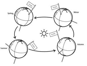
Seasons
Légende : This diagram shows the Earth at the June solstice which is known as the summer solstice in the Northern Hemisphere and the winter solstice in the Southern Hemisphere. The Earth’s axis of rotation is tilted from the axis of the Earth’s orbit around the Sun by 23.4°. Here we see light from the sun represented as parallel lines, in the diagram the Sun would lie far off the right-hand edge. Five lines are marked with angles. These lines hit the Earth at special latitudes. From top to bottom these lines hit the Earth at the North Pole, the Tropic of Cancer, the Equator, the Tropic of Capricorn and the Antarctic Circle. The lines are shown hitting the Earth at the longitude where it is currently noon. For the last four lines, the angles marked show the angle above the horizon (the altitude) which the Sun appears in the sky at at local noon.
At the June solstice, the Sun will appear directly overhead at local noon on every point on the Tropic of Capricorn. By contrast the Sun reaches a maximum altitude of 0° at local noon on every point in the Antarctic Circle. This means the Sun never rises and every point south of the Antarctic Circle experiences a long Polar Night. By contrast the Sun never sets on this day north of the Arctic Circle and the regions here experience a Polar Day. The at the North Pole the Sun will remain at a constant altitude all day. This altitude will be the angle 180°-156.6° (23.4°).
The altitude the Sun appears at is important as it defines how spread out the Sun’s rays are on the Earth’s surface. Look at the thick, faint parallel lines in the background. Notice how at the Tropic of Cancer the area the lines intersect with the Earth’s surface perpendicularly and the line only covers a small part of the Earth’s surface. Now look at a line near the Tropic of Capricorn and see that this intersects with the Earth at a grazing angle and the line is spread out, covering a much wider area of the Earth’s surface. This means that a given amount of light from the Sun that hits the Tropic of Cancer is more concentrated and the same amount of light hitting the Tropic of Capricorn would be more spread out. This leads to more energy per unit area from the Sun hitting the Tropic of Cancer and less energy per unit area hitting the Tropic of Capricorn. This means it will be warmer at the Tropic of Cancer than at the Tropic of Capricorn. It is thus summer at the Tropic of Cancer and winter at the Tropic of Capricorn.
Six months later this situation will be reversed and it will be summer at the Tropic of Capricorn and winter at the Tropic of Cancer.
Crédit : Maria Cristina Fortuna/IAU OAE
License: CC-BY-4.0 Creative Commons (CC) Attribution 4.0 International (CC BY 4.0) Icônes
Activités associées
Seasons Around the World
astroEDU educational activity (links to astroEDU website) Description: Demonstrate the seasons on Earth using a model.
License: CC-BY-4.0 Creative Commons (CC) Attribution 4.0 International (CC BY 4.0) Icônes
Mots clés :
Hands-on
, Model
Tranches d'âge :
6-8
, 8-10
, 10-12
Niveau scolaire :
Collège
, Primaire
Domaines d'apprentissage :
Modélisation
, Apprentissage par enquête
Coûts :
Moyen
Durée :
45min
Taille du groupe :
Par groupe
Compétences :
Analyser et interpréter des données
, Poser des questions
, Construire des explications
, Développer et utiliser des modèles
, Planifier et mener des enquêtes
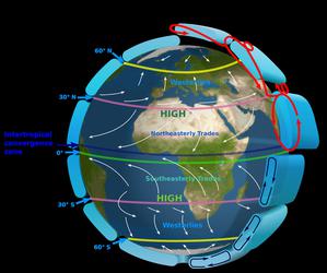
The Intertropical Convergence Zone
astroEDU educational activity (links to astroEDU website) Description: The air circulation system: how are winds created?
License: CC-BY-4.0 Creative Commons (CC) Attribution 4.0 International (CC BY 4.0) Icônes
Mots clés :
Climate
, Updraft
, Convection
, Winds
Tranches d'âge :
12-14
, 14-16
Niveau scolaire :
Collège
Domaines d'apprentissage :
Groupes de discussion
, Modélisation
, Apprentissage par enquête
Coûts :
Moyen
Durée :
1h
Taille du groupe :
Par groupe
Compétences :
Communiquer des informations
, Construire des explications
, Développer et utiliser des modèles
, S'engager dans des arguments fondés sur des preuves
, Planifier et mener des enquêtes
The Quest for Longitude
astroEDU educational activity (links to astroEDU website) Description: How to navigate at sea like an explorer?
License: CC-BY-4.0 Creative Commons (CC) Attribution 4.0 International (CC BY 4.0) Icônes
Mots clés :
Clocks
, Geography
, Coordinates
, Celestial navigation
, James Cook
, Exploration
Tranches d'âge :
14-16
, 16-19
Niveau scolaire :
Collège
, Secondaire
Domaines d'apprentissage :
Groupes de discussion
, Modélisation
, Apprentissage par enquête
Coûts :
Faible
Durée :
2h
Taille du groupe :
Par groupe
Compétences :
Analyser et interpréter des données
, Poser des questions
, Communiquer des informations
, Développer et utiliser des modèles
, Planifier et mener des enquêtes
, Utiliser les mathématiques et la pensée computationnelle

Navigating with the Kamal – Northern Hemisphere
astroEDU educational activity (links to astroEDU website) Description: How did Arabian sailors navigate at sea?
License: CC-BY-4.0 Creative Commons (CC) Attribution 4.0 International (CC BY 4.0) Icônes
Mots clés :
History
, Geography
, Coordinates
, Celestial navigation
, Arabia
, Kamal
Tranches d'âge :
14-16
, 16-19
Niveau scolaire :
Collège
, Secondaire
Domaines d'apprentissage :
Modélisation
, Apprentissage par enquête
Coûts :
Faible
Durée :
1h 30m
Taille du groupe :
Par groupe
Compétences :
Analyser et interpréter des données
, Poser des questions
, Communiquer des informations
, Développer et utiliser des modèles
, Planifier et mener des enquêtes
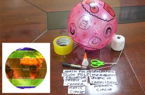
Discover Earth's climate with a balloon
astroEDU educational activity (links to astroEDU website) Description: Discover the secrets of Earth's climate zones with a hands-on experience
License: CC-BY-4.0 Creative Commons (CC) Attribution 4.0 International (CC BY 4.0) Icônes
Tranches d'âge :
8-10
, 10-12
Niveau scolaire :
Collège
, Primaire
Domaines d'apprentissage :
Activité ludique
, Apprentissage par découverte guidée
, Modélisation
, Basée sur l'observation
, Apprentissage par projet
, Apprentissage par enquête
Coûts :
Faible
Durée :
45min
Taille du groupe :
Par groupe
Compétences :
Poser des questions
, Construire des explications
, Développer et utiliser des modèles
Ceci pourrait vous intéresser également


- Ressources
- Moteur de recherche des ressources pédagogiques
- Parcourir les ressources pédagogiques par Sujet
- Parcourir les images
- AstroEdu - Activités en classe
- Grandes Idées - Littéracie en astronomie
- Glossaire
- Rapports de l'OAE
- L'astronomie pour l'Education à travers le monde
- Sélection de ressources externes