Terme du glossaire : Coordonnées célestes
Description : Depuis la Terre, nous percevons les objets célestes comme étant situés sur une sphère, traditionnellement appelée sphère céleste. Nous pouvons décrire n'importe quelle position sur cette sphère à l'aide de deux nombres. Toute méthode permettant d'attribuer deux nombres à une position dans le ciel est appelée système de coordonnées célestes, et les nombres sont appelés coordonnées (célestes) de l'objet.
À la surface de la Terre, nous utilisons la latitude et la longitude géographiques dans le même but et, en fait, une façon de définir les coordonnées célestes en découle : les points du ciel situés directement au-dessus de l'équateur terrestre forment l'équateur céleste, et le point situé directement au-dessus d'une certaine position sur le globe terrestre se voit attribuer des nombres d'une manière similaire à la latitude/longitude du point de base.
Les astronomes utilisent différents types de systèmes de coordonnées, dont un qui tient compte de la rotation quotidienne de la Terre, de sorte que les coordonnées soient universelles et utilisables partout sur Terre. Cela permet également de s'assurer que les coordonnées d'une étoile, par exemple, ne changent pas de manière significative au fil des jours, des mois ou des années.
Termes associés :
Voir ce terme dans d'autres langues
Statut du terme et de sa définition : La définition initiale de ce terme en anglais a été aprouvée par un·e spécialiste de la recherche en astronomie et un·e spécialiste de l’éducation La traduction de ce terme et de sa définition ont été aprouvées par un·e spécialiste de la recherche en astronomie et un·e spécialiste de l’éducation
Le glossaire multilangue de l'OAE est un projet du Bureau de l'IAU de l'Astronomie pour l'Education (OAE) en collaboration avec le Bureau de l'IAU de diffusion de l'Astronomie (OAO). Les termes et définitions ont été choisis, écrits et relues grâce à un effort collectif de l'OAE, les Centres et les Noeuds de l'OAE, les Coordinateurs Nationaux de l'Astronomie pour l'Education de l'OAE(NAECs) et d'autres volontaires. La liste complète des crédits pour ce projet est disponible ici . Tous les termes du glossaire et leur définition sont déposés sous licence Creative Commons CC BY-4.0 et doivent être créditées au nom de "IAU OAE".
Si vous constatez une erreur dans ce terme ou sa définition, veuillez nous contacter .
Dans d'autres langues
- Arabe: الإحداثيات السماوية
- Allemand: Himmelskoordinaten
- Anglais: Celestial Coordinates
- Espagnol: Coordenadas celestes
- Italien: Coordinate celesti
- Japonais: 天球座標系 (Liens externes)
- Coréen: 천구좌표
- Portugais brésilien: Coordenadas celestes
- Chinois simplifié: 天球坐标
- Chinois traditionnel: 天球坐標
Diagrammes associés
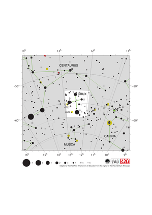
Crux Constellation Map
Légende : The constellation Crux (commonly known as the Southern Cross or Crux Australis) showing its bright stars and surrounding constellations. The Southern Cross is surrounding by (going clockwise from the top) Centaurus, Carina and Musca. The brightest star is alpha Crucis which appears at the bottom of the constellation's famous kite shape. The Southern Cross is visible from southern and equatorial regions of the world. In more southerly parts of the world it is circumpolar so is always above the horizon. In other parts of the southern hemisphere and in equatorial regions it is most visible in the evenings in the southern hemisphere autumn.
The yellow circles show the locations of two open clusters, NGC 4755 (known as the Jewel Box) and NGC 4609.
The line joining gamma and alpha Crucis (the third and first brightest stars in the Southern Cross) points in the approximate direction of the South Celestial Pole. This has led to the Southern Cross playing an important role in celestial navigation, allowing navigators from different astronomical traditions to find their bearings.
The y-axis of this diagram is in degrees of declination with north as up and the x-axis is in hours of right ascension with east to the left. The sizes of the stars marked here relate to the star's apparent magnitude, a measure of its apparent brightness. The larger dots represent brighter stars. The Greek letters mark the brightest stars in the constellation. These are ranked by brightness with the brightest star being labeled alpha, the second brightest beta, etc., although this ordering is not always followed exactly. The dotted boundary lines mark the IAU's boundaries of the constellations and the solid green lines mark one of the common forms used to represent the figures of the constellations. Neither the constellation boundaries, nor the lines joining the stars appear on the sky.
Crédit : Adapted by the IAU Office of Astronomy for Education from the original by IAU/Sky & Telescope.
License: CC-BY-4.0 Creative Commons (CC) Attribution 4.0 International (CC BY 4.0) Icônes
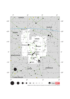
Orion Constellation Map
Légende : The constellation Orion along with its bright stars and surrounding constellations. Orion is surrounded by (going clockwise from the top) Taurus, Eridanus, Lepus, Monoceros and Gemini. Orion’s brightest stars Betelgeuse and Rigel appear at the northern (upper on this diagram) and southern (lower) end of the constellation respectively with the famous three star “belt” in the middle.
Orion spans the celestial equator and is thus visible at some time in the year from all of planet Earth. In the most arctic or antarctic regions of the world, some parts of the constellation may not be visible. Orion is most visible in the evenings in the northern hemisphere winter and southern hemisphere summer. The blue line above Orion marks the ecliptic, the path the Sun appears to travel across the sky over the course of a year. The Sun never passes through Orion, but one can occasionally find the other planets of the Solar System and the Moon in Orion.
Just south of Orion’s belt lie two Messier objects M42 (the Orion nebula) and M43, marked by green squares. These nebulae along with M78 (here the green square to the left of the belt) are part of the huge Orion Molecular Cloud Complex. This covers most of the constellation and includes regions where these molecular clouds are collapsing to form young starts.
The y-axis of this diagram is in degrees of declination with north as up and the x-axis is in hours of right ascension with east to the left. The sizes of the stars marked here relate to the star's apparent magnitude, a measure of its apparent brightness. The larger dots represent brighter stars. The Greek letters mark the brightest stars in the constellation. These are ranked by brightness with the brightest star being labeled alpha, the second brightest beta, etc., although this ordering is not always followed exactly. The circle around Betelgeuse indicates that it is a variable star. The dotted boundary lines mark the IAU's boundaries of the constellations and the solid green lines mark one of the common forms used to represent the figures of the constellations. Neither the constellation boundaries, nor the line marking the ecliptic, nor the lines joining the stars appear on the sky.
Crédit : Adapted by the IAU Office of Astronomy for Education from the original by IAU/Sky & Telescope
License: CC-BY-4.0 Creative Commons (CC) Attribution 4.0 International (CC BY 4.0) Icônes
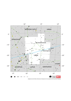
Libra Constellation Map
Légende : The constellation Libra along with its bright stars and surrounding constellations. Libra is surrounded by (going clockwise from the top) Serpens Caput, Virgo, Hydra, Centaurus, Lupus, Scorpius and Ophiuchus. Libra lies on the ecliptic (shown here as a blue line), this is the path the Sun appears to take across the sky over the course of a year. The Sun is in Libra from late October to late November. The other planets of the Solar System can often be found in Libra.
Libra lies just south of the celestial equator and is thus visible at some time in all but the most arctic regions. Libra is most visible in the evenings in the northern hemisphere late spring/early summer and southern hemisphere late autumn/early winter.
The y-axis of this diagram is in degrees of declination with north as up and the x-axis is in hours of right ascension with east to the left. The sizes of the stars marked here relate to the star's apparent magnitude, a measure of its apparent brightness. The larger dots represent brighter stars. The Greek letters mark the brightest stars in the constellation. These are ranked by brightness with the brightest star being labeled alpha, the second brightest beta, etc., although this ordering is not always followed exactly. The dotted boundary lines mark the IAU's boundaries of the constellations and the solid green lines mark one of the common forms used to represent the figures of the constellations. Neither the constellation boundaries, nor the line marking the ecliptic, nor the lines joining the stars appear on the sky.
Crédit : Adapted by the IAU Office of Astronomy for Education from the original by IAU/Sky & Telescope
License: CC-BY-4.0 Creative Commons (CC) Attribution 4.0 International (CC BY 4.0) Icônes
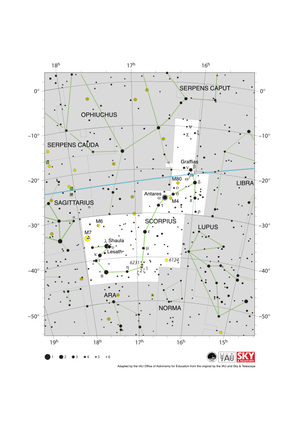
Scorpius Constellation Map
Légende : The constellation Scorpius (often commonly called Scorpio) along with its bright stars and surrounding constellations. Scorpius is surrounded by (going clockwise from the top) Ophiuchus, Serpens Caput, Libra, Lupus, Norma, Ara, Corona Australis and Sagittarius. Scorpius’s brightest star Antares appears in the heart of the constellation with the famous tail of Scoprius in the south-east (lower left). Scorpius lies on the ecliptic (shown here as a blue line), this is the path the Sun appears to take across the sky over the course of a year. The Sun only spends a short amount of time in late November in Scorpius. The other planets of the Solar System can often be found in Scorpius.
Scorpius lies south of the celestial equator. The whole constellation is not visible from the most arctic regions of the world with parts of Scorpius obscured for observers in northern parts of Asia, Europe and North America. Scorpius is most visible in the evenings in the northern hemisphere summer and southern hemisphere winter.
The yellow circles mark the positions of the open clusters M6, M7 & NGC 6231 while the yellow circles with plus signs superimposed on them mark the globular clusters M4 and M80.
The y-axis of this diagram is in degrees of declination with north as up and the x-axis is in hours of right ascension with east to the left. The sizes of the stars marked here relate to the star's apparent magnitude, a measure of its apparent brightness. The larger dots represent brighter stars. The Greek letters mark the brightest stars in the constellation. These are ranked by brightness with the brightest star being labeled alpha, the second brightest beta, etc., although this ordering is not always followed exactly. The circle around Antares indicates that it is a variable star. The dotted boundary lines mark the IAU's boundaries of the constellations and the solid green lines mark one of the common forms used to represent the figures of the constellations. The blue line marks the ecliptic, the path the Sun appears to travel across the sky over the course of one year. Neither the constellation boundaries, nor the line marking the ecliptic, nor the lines joining the stars appear on the sky.
Crédit : Adapted by the IAU Office of Astronomy for Education from the original by IAU/Sky & Telescope
License: CC-BY-4.0 Creative Commons (CC) Attribution 4.0 International (CC BY 4.0) Icônes
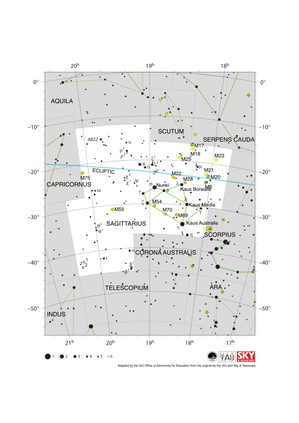
Sagittarius Constellation Map
Légende : The constellation Sagittarius along with its bright stars and surrounding constellations. Sagittarius is surrounded by (going clockwise from the top) Aquila, Scutum, Serpens Cauda, Ophiuchus, Scorpius, Corona Australis, Telescopium, Microscopium and Capricornus. The brighter stars in Sagittarius form a distinctive teapot shape. Sagittarius lies on the ecliptic (shown here as a blue line), this is the path the Sun appears to take across the sky over the course of a year. The Sun is in Sagittarius from mid December to mid January. The other planets of the Solar System can often be found in Sagittarius.
Sagittarius lies south of the celestial equator. The famous teapot asterism is visible for all but the most arctic regions of the world but the most southerly parts of the constellation are not visible in northern parts of Asia, Europe and North America. Sagittarius is most visible in the evenings in the northern hemisphere summer and southern hemisphere winter.
The supermassive black hole Sagittarius A* which lies at the center of our Milky Way Galaxy is sits on the western (here right-hand) edge of Sagittarius. Due to it covering an area at the center of our Galaxy, Sagittarius is home to many star clusters including open clusters (marked here with yellow circles) and globular clusters (marked here with yellow circles with + signs superimposed on them). Three nebulae are also marked here with green squares.
The y-axis of this diagram is in degrees of declination with north as up and the x-axis is in hours of right ascension with east to the left. The sizes of the stars marked here relate to the star's apparent magnitude, a measure of its apparent brightness. The larger dots represent brighter stars. The Greek letters mark the brightest stars in the constellation. These are ranked by brightness with the brightest star being labeled alpha, the second brightest beta, etc., although this ordering is not always followed exactly. The dotted boundary lines mark the IAU's boundaries of the constellations and the solid green lines mark one of the common forms used to represent the figures of the constellations. Neither the constellation boundaries, nor the line marking the ecliptic, nor the lines joining the stars appear on the sky.
Crédit : Adapted by the IAU Office of Astronomy for Education from the original by IAU/Sky & Telescope
License: CC-BY-4.0 Creative Commons (CC) Attribution 4.0 International (CC BY 4.0) Icônes
Activités associées

Navigation in the Ancient Mediterranean and Beyond
astroEDU educational activity (links to astroEDU website) Description: Learn the ancient skill of Celestial Navigation
License: CC-BY-4.0 Creative Commons (CC) Attribution 4.0 International (CC BY 4.0) Icônes
Mots clés :
History
, Geography
, Celestial navigation
Tranches d'âge :
14-16
, 16-19
Niveau scolaire :
Collège
, Secondaire
Domaines d'apprentissage :
Groupes de discussion
, Modélisation
, Apprentissage par enquête
Coûts :
Faible
Durée :
1h 30m
Taille du groupe :
Par groupe
Compétences :
Analyser et interpréter des données
, Poser des questions
, Communiquer des informations
, Développer et utiliser des modèles
, Planifier et mener des enquêtes
, Utiliser les mathématiques et la pensée computationnelle


- Ressources
- Moteur de recherche des ressources pédagogiques
- Parcourir les ressources pédagogiques par Sujet
- Parcourir les images
- AstroEdu - Activités en classe
- Grandes Idées - Littéracie en astronomie
- Glossaire
- Rapports de l'OAE
- L'astronomie pour l'Education à travers le monde
- Sélection de ressources externes