Termo do glossário: Coordenadas celestes
Descrição: Da Terra, percebemos os objetos celestes como se estivessem localizados em uma esfera, tradicionalmente chamada de esfera celeste. Podemos descrever qualquer posição nessa esfera usando dois números. Todo método para atribuir dois desses números a uma posição no céu é chamado de sistema de coordenadas celestes, e os números são chamados de coordenadas (celestes) do objeto.
Na superfície da Terra, usamos a latitude e a longitude geográficas para a mesma finalidade e, de fato, uma maneira de definir as coordenadas celestes é derivada disso: os pontos no céu que estão diretamente acima do equador da Terra formam o equador celeste, e o ponto diretamente acima de uma certa posição no globo terrestre recebe números de maneira semelhante à latitude/longitude do ponto de base.
Os astrônomos usam diferentes tipos de sistemas de coordenadas, incluindo um número que leva em conta a rotação diária da Terra, de modo que as coordenadas são universais e podem ser usadas em qualquer lugar da Terra. Isso também garante que as coordenadas de, por exemplo, uma estrela, não mudem significativamente em escalas de tempo de dias, meses ou anos.
Termos relacionados:
Ver este termo em outros idiomas
Status do termo e da definição: A definição original deste termo em inglês foi aprovada por um astrônomo(a) pesquisador(a) e um(a) professor(a) A tradução deste termo e de sua definição ainda aguarda aprovação
O Glossário Multilíngue da OAE é um projeto do Escritório da IAU de Astronomia para a Educação (OAE) em colaboração com o Escritório da IAU para Divulgação da Astronomia (OAO). Os termos e definições foram selecionados, escritos e revisados por meio de um esforço coletivo da OAE, dos Centros e Nós da OAE, dos Coordenadores Nacionais de Educação em Astronomia (NAECs) da OAE e de outros voluntários. Você pode encontrar uma lista completa dos créditos aqui. Todos os termos do glossário e suas definições são disponibilizados sob uma licença Creative Commons CC BY-4.0 e devem ser creditados à "IAU OAE".
Se você notar algum erro factual ou de tradução neste termo do glossário ou em sua definição, por favor entre em contato.
Em outros idiomas
- Árabe: الإحداثيات السماوية
- Alemão: Himmelskoordinaten
- Inglês: Celestial Coordinates
- Espanhol: Coordenadas celestes
- Francês: Coordonnées célestes
- Italiano: Coordinate celesti
- Japonês: 天球座標系 (link externo)
- Coreano: 천구좌표
- Chinês Simplificado: 天球坐标
- Chinês Tradicional: 天球坐標
Diagramas relacionados
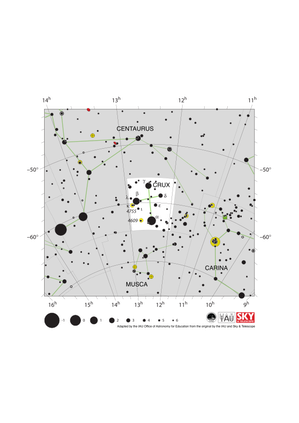
Crux Constellation Map
Legenda: The constellation Crux (commonly known as the Southern Cross or Crux Australis) showing its bright stars and surrounding constellations. The Southern Cross is surrounding by (going clockwise from the top) Centaurus, Carina and Musca. The brightest star is alpha Crucis which appears at the bottom of the constellation's famous kite shape. The Southern Cross is visible from southern and equatorial regions of the world. In more southerly parts of the world it is circumpolar so is always above the horizon. In other parts of the southern hemisphere and in equatorial regions it is most visible in the evenings in the southern hemisphere autumn.
The yellow circles show the locations of two open clusters, NGC 4755 (known as the Jewel Box) and NGC 4609.
The line joining gamma and alpha Crucis (the third and first brightest stars in the Southern Cross) points in the approximate direction of the South Celestial Pole. This has led to the Southern Cross playing an important role in celestial navigation, allowing navigators from different astronomical traditions to find their bearings.
The y-axis of this diagram is in degrees of declination with north as up and the x-axis is in hours of right ascension with east to the left. The sizes of the stars marked here relate to the star's apparent magnitude, a measure of its apparent brightness. The larger dots represent brighter stars. The Greek letters mark the brightest stars in the constellation. These are ranked by brightness with the brightest star being labeled alpha, the second brightest beta, etc., although this ordering is not always followed exactly. The dotted boundary lines mark the IAU's boundaries of the constellations and the solid green lines mark one of the common forms used to represent the figures of the constellations. Neither the constellation boundaries, nor the lines joining the stars appear on the sky.
Crédito: Adapted by the IAU Office of Astronomy for Education from the original by IAU/Sky & Telescope.
License: CC-BY-4.0 Creative Commons Attribution 4.0 International (CC BY 4.0) ícones
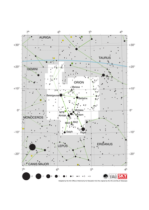
Orion Constellation Map
Legenda: The constellation Orion along with its bright stars and surrounding constellations. Orion is surrounded by (going clockwise from the top) Taurus, Eridanus, Lepus, Monoceros and Gemini. Orion’s brightest stars Betelgeuse and Rigel appear at the northern (upper on this diagram) and southern (lower) end of the constellation respectively with the famous three star “belt” in the middle.
Orion spans the celestial equator and is thus visible at some time in the year from all of planet Earth. In the most arctic or antarctic regions of the world, some parts of the constellation may not be visible. Orion is most visible in the evenings in the northern hemisphere winter and southern hemisphere summer. The blue line above Orion marks the ecliptic, the path the Sun appears to travel across the sky over the course of a year. The Sun never passes through Orion, but one can occasionally find the other planets of the Solar System and the Moon in Orion.
Just south of Orion’s belt lie two Messier objects M42 (the Orion nebula) and M43, marked by green squares. These nebulae along with M78 (here the green square to the left of the belt) are part of the huge Orion Molecular Cloud Complex. This covers most of the constellation and includes regions where these molecular clouds are collapsing to form young starts.
The y-axis of this diagram is in degrees of declination with north as up and the x-axis is in hours of right ascension with east to the left. The sizes of the stars marked here relate to the star's apparent magnitude, a measure of its apparent brightness. The larger dots represent brighter stars. The Greek letters mark the brightest stars in the constellation. These are ranked by brightness with the brightest star being labeled alpha, the second brightest beta, etc., although this ordering is not always followed exactly. The circle around Betelgeuse indicates that it is a variable star. The dotted boundary lines mark the IAU's boundaries of the constellations and the solid green lines mark one of the common forms used to represent the figures of the constellations. Neither the constellation boundaries, nor the line marking the ecliptic, nor the lines joining the stars appear on the sky.
Crédito: Adapted by the IAU Office of Astronomy for Education from the original by IAU/Sky & Telescope
License: CC-BY-4.0 Creative Commons Attribution 4.0 International (CC BY 4.0) ícones
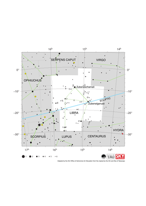
Libra Constellation Map
Legenda: The constellation Libra along with its bright stars and surrounding constellations. Libra is surrounded by (going clockwise from the top) Serpens Caput, Virgo, Hydra, Centaurus, Lupus, Scorpius and Ophiuchus. Libra lies on the ecliptic (shown here as a blue line), this is the path the Sun appears to take across the sky over the course of a year. The Sun is in Libra from late October to late November. The other planets of the Solar System can often be found in Libra.
Libra lies just south of the celestial equator and is thus visible at some time in all but the most arctic regions. Libra is most visible in the evenings in the northern hemisphere late spring/early summer and southern hemisphere late autumn/early winter.
The y-axis of this diagram is in degrees of declination with north as up and the x-axis is in hours of right ascension with east to the left. The sizes of the stars marked here relate to the star's apparent magnitude, a measure of its apparent brightness. The larger dots represent brighter stars. The Greek letters mark the brightest stars in the constellation. These are ranked by brightness with the brightest star being labeled alpha, the second brightest beta, etc., although this ordering is not always followed exactly. The dotted boundary lines mark the IAU's boundaries of the constellations and the solid green lines mark one of the common forms used to represent the figures of the constellations. Neither the constellation boundaries, nor the line marking the ecliptic, nor the lines joining the stars appear on the sky.
Crédito: Adapted by the IAU Office of Astronomy for Education from the original by IAU/Sky & Telescope
License: CC-BY-4.0 Creative Commons Attribution 4.0 International (CC BY 4.0) ícones
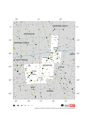
Scorpius Constellation Map
Legenda: The constellation Scorpius (often commonly called Scorpio) along with its bright stars and surrounding constellations. Scorpius is surrounded by (going clockwise from the top) Ophiuchus, Serpens Caput, Libra, Lupus, Norma, Ara, Corona Australis and Sagittarius. Scorpius’s brightest star Antares appears in the heart of the constellation with the famous tail of Scoprius in the south-east (lower left). Scorpius lies on the ecliptic (shown here as a blue line), this is the path the Sun appears to take across the sky over the course of a year. The Sun only spends a short amount of time in late November in Scorpius. The other planets of the Solar System can often be found in Scorpius.
Scorpius lies south of the celestial equator. The whole constellation is not visible from the most arctic regions of the world with parts of Scorpius obscured for observers in northern parts of Asia, Europe and North America. Scorpius is most visible in the evenings in the northern hemisphere summer and southern hemisphere winter.
The yellow circles mark the positions of the open clusters M6, M7 & NGC 6231 while the yellow circles with plus signs superimposed on them mark the globular clusters M4 and M80.
The y-axis of this diagram is in degrees of declination with north as up and the x-axis is in hours of right ascension with east to the left. The sizes of the stars marked here relate to the star's apparent magnitude, a measure of its apparent brightness. The larger dots represent brighter stars. The Greek letters mark the brightest stars in the constellation. These are ranked by brightness with the brightest star being labeled alpha, the second brightest beta, etc., although this ordering is not always followed exactly. The circle around Antares indicates that it is a variable star. The dotted boundary lines mark the IAU's boundaries of the constellations and the solid green lines mark one of the common forms used to represent the figures of the constellations. The blue line marks the ecliptic, the path the Sun appears to travel across the sky over the course of one year. Neither the constellation boundaries, nor the line marking the ecliptic, nor the lines joining the stars appear on the sky.
Crédito: Adapted by the IAU Office of Astronomy for Education from the original by IAU/Sky & Telescope
License: CC-BY-4.0 Creative Commons Attribution 4.0 International (CC BY 4.0) ícones
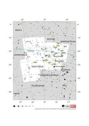
Sagittarius Constellation Map
Legenda: The constellation Sagittarius along with its bright stars and surrounding constellations. Sagittarius is surrounded by (going clockwise from the top) Aquila, Scutum, Serpens Cauda, Ophiuchus, Scorpius, Corona Australis, Telescopium, Microscopium and Capricornus. The brighter stars in Sagittarius form a distinctive teapot shape. Sagittarius lies on the ecliptic (shown here as a blue line), this is the path the Sun appears to take across the sky over the course of a year. The Sun is in Sagittarius from mid December to mid January. The other planets of the Solar System can often be found in Sagittarius.
Sagittarius lies south of the celestial equator. The famous teapot asterism is visible for all but the most arctic regions of the world but the most southerly parts of the constellation are not visible in northern parts of Asia, Europe and North America. Sagittarius is most visible in the evenings in the northern hemisphere summer and southern hemisphere winter.
The supermassive black hole Sagittarius A* which lies at the center of our Milky Way Galaxy is sits on the western (here right-hand) edge of Sagittarius. Due to it covering an area at the center of our Galaxy, Sagittarius is home to many star clusters including open clusters (marked here with yellow circles) and globular clusters (marked here with yellow circles with + signs superimposed on them). Three nebulae are also marked here with green squares.
The y-axis of this diagram is in degrees of declination with north as up and the x-axis is in hours of right ascension with east to the left. The sizes of the stars marked here relate to the star's apparent magnitude, a measure of its apparent brightness. The larger dots represent brighter stars. The Greek letters mark the brightest stars in the constellation. These are ranked by brightness with the brightest star being labeled alpha, the second brightest beta, etc., although this ordering is not always followed exactly. The dotted boundary lines mark the IAU's boundaries of the constellations and the solid green lines mark one of the common forms used to represent the figures of the constellations. Neither the constellation boundaries, nor the line marking the ecliptic, nor the lines joining the stars appear on the sky.
Crédito: Adapted by the IAU Office of Astronomy for Education from the original by IAU/Sky & Telescope
License: CC-BY-4.0 Creative Commons Attribution 4.0 International (CC BY 4.0) ícones
Atividades relacionadas

Navigation in the Ancient Mediterranean and Beyond
astroEDU educational activity (links to astroEDU website) Description: Learn the ancient skill of Celestial Navigation
License: CC-BY-4.0 Creative Commons Attribution 4.0 International (CC BY 4.0) ícones
Tags:
History
, Geography
, Celestial navigation
Faixas etárias:
14-16
, 16-19
Nível de ensino:
Ensino fundamental
, Médio
Áreas de aprendizagem:
Grupos de discussão
, Modelagem
, Aprendizagem por investigação estruturada
Custos:
Baixo custo
Duração:
1 hour 30 mins
Tamanho do grupo:
Grupo
Habilidades:
Analisar e interpretar dados
, Fazer perguntas
, Comunicar informações
, Desenvolver e usar modelos
, Planejar e realizar pesquisas
, Usar matemática e pensamento computacional