Glossary term: 極圈
Description: 極圈是地球上兩條特定的緯線圈。位於北緯66°33′48.8″的極圈稱為北極圈,位於南緯66°33′48.8″的極圈稱為南極圈。由於地球自轉軸是傾斜的,北極圈以北和南極圈以南地區的冬季為“極夜”,夏季為“極晝”。極夜期間,太陽在地平線以下的時間超過24小時,暗夜可持續數月。極晝期間,太陽在地平線以上的時間超過24小時,白晝可持續數月。越靠近極點,則極晝和極夜最長。對於每個極地區域,極夜出現在冬至前後,極晝出現在夏至前後。
Related Terms:
See this term in other languages
Term and definition status: The original definition of this term in English have been approved by a research astronomer and a teacher The translation of this term and its definition is still awaiting approval
This is an automated transliteration of the simplified Chinese translation of this term
The OAE Multilingual Glossary is a project of the IAU Office of Astronomy for Education (OAE) in collaboration with the IAU Office of Astronomy Outreach (OAO). The terms and definitions were chosen, written and reviewed by a collective effort from the OAE, the OAE Centers and Nodes, the OAE National Astronomy Education Coordinators (NAECs) and other volunteers. You can find a full list of credits here. All glossary terms and their definitions are released under a Creative Commons CC BY-4.0 license and should be credited to "IAU OAE".
If you notice a factual or translation error in this glossary term or definition then please get in touch.
In Other Languages
- 阿拉伯語: الدائرة القطبية
- 德語: Polarkreis
- 英語: Polar Circle
- 西班牙語: Círculo Polar Ártico
- 法語: Cercle polaire
- 義大利語: Circolo polare
- 韓語: 극권
- 馬拉提語: ध्रुवीय वर्तुळ
- 尼泊爾語: ध्रुवीय वृत्त
- 巴西葡萄牙語: Círculo Polar
- 簡體中文: 极圈
Related Media
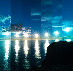
當太陽反彈時
Caption: 這張照片拍攝於挪威的北角。由於該地的緯度原因,從四月到八月的夏季,太陽從未真正落下。這就形成了獨特的連續白晝現象,即所謂的極晝。這組迷人的照片拍攝於 2022 年,展示了太陽每 30 分鐘穿越地平線的不懈旅程。當太陽位於天空的最低點時,它不會落下,而是看起來像是從地平線反彈回來的。照片最右邊的地球就像一個哨兵,標誌著歐洲大陸的最北端。
Credit: Milos Obert/IAU OAE (CC BY 4.0)
License: CC-BY-4.0 Creative Commons 姓名標示 4.0 國際 (CC BY 4.0) icons
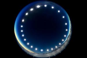
日食鐘——極晝中的日食
Caption: 這幅圖像是於2021年12月4日的日全食期間在南極洲的聯合冰川拍攝的,由24小時內先後拍攝到的多張照片組合而成,展示了太陽的晝弧。它展示了被稱為“極晝”的獨特現象——在極晝中,太陽在天空中巡行而不落下。在極晝期間,極圈內的地區會經歷24小時的連續日照,太陽長時間不落山。這幅圖像還提供了罕見的日食視角——從地球看去,月球從太陽和地球之間穿過。在圖像最下方的太陽照片中,月球覆蓋了太陽圓面。
Credit: Stephanie Ziyi Ye/IAU OAE (CC BY 4.0)
License: CC-BY-4.0 Creative Commons 姓名標示 4.0 國際 (CC BY 4.0) icons
Related Diagrams

Latitude and Longitude
Caption: Two views of the Earth, one viewing the Northern Hemisphere, one viewing the Southern Hemisphere. The Earth rotates around its axis, an imaginary line that runs through the Earth from the North Pole to the South Pole. The Equator is an imaginary line that is the same distant from both the North Pole and the South Pole.
The positions of two cities, Rome in the Northern Hemisphere and Sydney in the Southern Hemisphere are marked here with red dots. Arrows indicate the two spherical coordinates latitude and longitude.
Latitude marks the position north or south of the equator. Here we can see Rome has the letter N in its latitude as it is in the Northern Hemisphere and Sydney has the letter S in its latitude as it is in the Southern Hemisphere. Latitude can vary from 90° N at the North Pole to 0° at the Equator to 90° S at the South Pole.
Longitude measures the position around the equator. While the choice of the zero point for latitude as the equator seems obvious, the choice of the zero point for longitude is more subjective. By convention the zero point in longitude is the prime meridian which passes through the Royal Greenwich Observatory in the UK. This is marked here as a solid line originating at the North Pole. Longitude is measured in degrees east or west of the prime meridian. As both Rome and Sydney lie to the east of Greenwich, they have the letter E as part of their longitude. Moving west to east, longitude varies from 180° W on the other side of the world from the prime meridian to 0° on the prime meridian before reaching 180° E again on the other side of world from the prime meridian.
This diagram shows the Earth at the December solstice. Two views are presented, one viewing the Northern Hemisphere and one viewing the Southern Hemisphere about nine hours later. The shaded region shows the night side of the Earth, with the day side being lighter. As it is the December solstice, the Sun appears overhead at the Tropic of Capricorn. This is a line of constant latitude at 23°26′09.3″ S. Six months later, at the June solstice, the Sun will appear to be overhead at the Tropic of Cancer at 23°26′09.3″ N. As the Sun appears over the Tropic of Capricorn more of the Southern Hemisphere is illuminated than the Northern Hemisphere. Indeed below the Antarctic Circle (the Polar Circle around the South Pole) the Sun does not set at this time of year leading to a Polar Day. Conversely, north of the Arctic Circle (the Polar Circle around the North Pole) the Sun does not rise at this time of year, leading to a Polar Night.
Credit: Maria Cristina Fortuna/IAU OAE
License: CC-BY-4.0 Creative Commons 姓名標示 4.0 國際 (CC BY 4.0) icons
Related Activities

Discover Earth's climate with a balloon
astroEDU educational activity (links to astroEDU website) Description: Discover the secrets of Earth's climate zones with a hands-on experience
License: CC-BY-4.0 Creative Commons 姓名標示 4.0 國際 (CC BY 4.0) icons
Age Ranges:
8-10
, 10-12
Education Level:
Middle School
, Primary
Areas of Learning:
Fun activity
, Guided-discovery learning
, Modelling
, Observation based
, Project-based learning
, Structured-inquiry learning
Costs:
Low Cost
Duration:
45 mins
Group Size:
Group
Skills:
Asking questions
, Constructing explanations
, Developing and using models

