Glossary term: 극권
Description: 극권은 지구상의 위도선입니다. 북위 66°33′48.8″에 있는 극권은 북극권이라고 하고, 남위 66°33′48.8″에 있는 극권은 남극권이라고 합니다. 지구의 자전축이 기울어져 있기 때문에 북극권의 북쪽과 남극권의 남쪽은 겨울에는 '극의 밤'을, 여름에는 '극의 낮'을 경험하게 됩니다. 극의 밤에는 태양이 24시간 이상 지평선 아래에 있으며 이 어둠의 기간은 몇 달 동안 지속될 수 있습니다. 극의 낮에는 태양이 24시간 이상 지평선 위에 있고 그 기간 역시 몇 달 동안 지속될 수 있습니다. 극의 낮과 밤은 극에 가까울수록 길어집니다. 극의 밤은 각 극지역의 동지 전후에 일어나고 극의 낮은 하지 전후에 일어납니다.
Related Terms:
See this term in other languages
Term and definition status: The original definition of this term in English have been approved by a research astronomer and a teacher The translation of this term and its definition is still awaiting approval
The OAE Multilingual Glossary is a project of the IAU Office of Astronomy for Education (OAE) in collaboration with the IAU Office of Astronomy Outreach (OAO). The terms and definitions were chosen, written and reviewed by a collective effort from the OAE, the OAE Centers and Nodes, the OAE National Astronomy Education Coordinators (NAECs) and other volunteers. You can find a full list of credits here. All glossary terms and their definitions are released under a Creative Commons CC BY-4.0 license and should be credited to "IAU OAE".
If you notice a factual or translation error in this glossary term or definition then please get in touch.
In Other Languages
- 아랍어: الدائرة القطبية
- 독일어: Polarkreis
- 영어: Polar Circle
- 스페인어: Círculo Polar Ártico
- 프랑스어: Cercle polaire
- 이탈리아어: Circolo polare
- 마라티어: ध्रुवीय वर्तुळ
- 네팔어: ध्रुवीय वृत्त
- 브라질 포르투갈어: Círculo Polar
- 중국어 간체: 极圈
- 중국어 번체: 極圈
Related Media
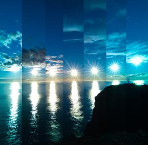
When the Sun Bounces
Caption: First place winner in the 2023 IAU OAE Astrophotography Contest, category of Still images of sunrise and sunset location over the year.
This image was taken at Norway's North Cape. Owing to the latitude of this location, the Sun never truly sets during the summer months, from around April to August. This results in the unique spectacle of continuous daylight, known as a polar day. This captivating series of images, taken in 2022, showcases the Sun's relentless journey across the horizon every 30 minutes. At its lowest point in the sky, the Sun does not set, but appears to bounce off the horizon. The globe on the far right in the photo stands as a sentinel, marking the northernmost point of the European continental mainland.
Credit: Milos Obert/IAU OAE (CC BY 4.0)
License: CC-BY-4.0 Creative Commons 저작자표시 4.0 국제 (CC BY 4.0) icons
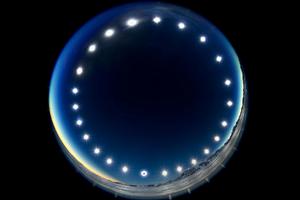
The Eclipse Clock-Eclipse on a Polar Day
Caption: First place winner in the 2023 IAU OAE Astrophotography Contest, category of Still images of day arcs of the Sun and Solargraphs.
Constructed by combining multiple images over the course of a 24-hour period, the image was captured in Union Glacier, Antarctica, during the total solar eclipse of 4 December 2021, and showcases the day arc of the Sun. It illustrates the unique phenomenon of a polar day, during which the Sun travels around the sky without setting. During polar days, areas within the polar circles experience 24 hours of continuous daylight, and the Sun doesn’t set for an extended period. The image also offers a rare perspective of a solar eclipse, where the Moon passes between the Sun and Earth, and as viewed from Earth. This can be seen in the lower image of the Sun, where the Moon covers the solar disc.
Credit: Stephanie Ziyi Ye/IAU OAE (CC BY 4.0)
License: CC-BY-4.0 Creative Commons 저작자표시 4.0 국제 (CC BY 4.0) icons
Related Diagrams

Latitude and Longitude
Caption: Two views of the Earth, one viewing the Northern Hemisphere, one viewing the Southern Hemisphere. The Earth rotates around its axis, an imaginary line that runs through the Earth from the North Pole to the South Pole. The Equator is an imaginary line that is the same distant from both the North Pole and the South Pole.
The positions of two cities, Rome in the Northern Hemisphere and Sydney in the Southern Hemisphere are marked here with red dots. Arrows indicate the two spherical coordinates latitude and longitude.
Latitude marks the position north or south of the equator. Here we can see Rome has the letter N in its latitude as it is in the Northern Hemisphere and Sydney has the letter S in its latitude as it is in the Southern Hemisphere. Latitude can vary from 90° N at the North Pole to 0° at the Equator to 90° S at the South Pole.
Longitude measures the position around the equator. While the choice of the zero point for latitude as the equator seems obvious, the choice of the zero point for longitude is more subjective. By convention the zero point in longitude is the prime meridian which passes through the Royal Greenwich Observatory in the UK. This is marked here as a solid line originating at the North Pole. Longitude is measured in degrees east or west of the prime meridian. As both Rome and Sydney lie to the east of Greenwich, they have the letter E as part of their longitude. Moving west to east, longitude varies from 180° W on the other side of the world from the prime meridian to 0° on the prime meridian before reaching 180° E again on the other side of world from the prime meridian.
This diagram shows the Earth at the December solstice. Two views are presented, one viewing the Northern Hemisphere and one viewing the Southern Hemisphere about nine hours later. The shaded region shows the night side of the Earth, with the day side being lighter. As it is the December solstice, the Sun appears overhead at the Tropic of Capricorn. This is a line of constant latitude at 23°26′09.3″ S. Six months later, at the June solstice, the Sun will appear to be overhead at the Tropic of Cancer at 23°26′09.3″ N. As the Sun appears over the Tropic of Capricorn more of the Southern Hemisphere is illuminated than the Northern Hemisphere. Indeed below the Antarctic Circle (the Polar Circle around the South Pole) the Sun does not set at this time of year leading to a Polar Day. Conversely, north of the Arctic Circle (the Polar Circle around the North Pole) the Sun does not rise at this time of year, leading to a Polar Night.
Credit: Maria Cristina Fortuna/IAU OAE
License: CC-BY-4.0 Creative Commons 저작자표시 4.0 국제 (CC BY 4.0) icons
Related Activities
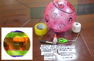
Discover Earth's climate with a balloon
astroEDU educational activity (links to astroEDU website) Description: Discover the secrets of Earth's climate zones with a hands-on experience
License: CC-BY-4.0 Creative Commons 저작자표시 4.0 국제 (CC BY 4.0) icons
Age Ranges:
8-10
, 10-12
Education Level:
Middle School
, Primary
Areas of Learning:
Fun activity
, Guided-discovery learning
, Modelling
, Observation based
, Project-based learning
, Structured-inquiry learning
Costs:
Low Cost
Duration:
45 mins
Group Size:
Group
Skills:
Asking questions
, Constructing explanations
, Developing and using models

