Glossary term: 二至點
Description: 地軸並非垂直於地球圍繞太陽的軌道平面,而是與垂直方向呈23.4度的傾斜角。因此,在地球軌道的不同位置上,地軸與太陽視線之間的角度在一年內是不同的。這種現象的實際效果是,對於地球上的觀測者來說,太陽在一天中達到地平線上最高點的高度會隨時間而變化。北半球夏至,同時也是南半球的冬至,大約發生在6月21日,此時太陽在北半球的高度到達一年中的最高點,同時在南半球的高度則到達最低點。而南半球夏至,同時也是北半球的冬至,大約發生在12月21日,此時太陽在南半球的高度到達最高點,同時在北半球的高度則到達最低點。
Related Terms:
See this term in other languages
Term and definition status: The original definition of this term in English have been approved by a research astronomer and a teacher The translation of this term and its definition is still awaiting approval
This is an automated transliteration of the simplified Chinese translation of this term
The OAE Multilingual Glossary is a project of the IAU Office of Astronomy for Education (OAE) in collaboration with the IAU Office of Astronomy Outreach (OAO). The terms and definitions were chosen, written and reviewed by a collective effort from the OAE, the OAE Centers and Nodes, the OAE National Astronomy Education Coordinators (NAECs) and other volunteers. You can find a full list of credits here. All glossary terms and their definitions are released under a Creative Commons CC BY-4.0 license and should be credited to "IAU OAE".
If you notice a factual or translation error in this glossary term or definition then please get in touch.
In Other Languages
- 阿拉伯語: الانقلاب الشمسي
- 德語: Sonnenwende
- 英語: Solstice
- 西班牙語: Solsticio
- 法語: Solstice
- 義大利語: Solstizio
- 巴西葡萄牙語: Solstício
- 簡體中文: 二至点
Related Media
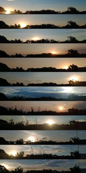
每月日落的地方
Caption: 這組圖片是在菲律賓布拉干省的聖拉斐爾用智能手機拍攝的,它捕捉到了地球軸向傾斜和環繞太陽運行所導致的日落位置在一年中的變化。從 2022 年 1 月到 12 月,每張圖片都反映了黃昏時分背景和太陽位置的變化。在十月,可以觀察到樹葉的變化和一根電線桿的出現。這組作品是地球與太陽之間的天體舞蹈以及地面自然景觀變化的視覺見證。
Credit: John Paul Pile/IAU OAE (CC BY 4.0)
License: CC-BY-4.0 Creative Commons 姓名標示 4.0 國際 (CC BY 4.0) icons
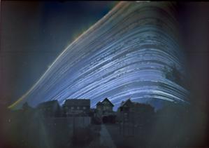
太陽的軌跡
Caption: 這幅令人陶醉的圖片於 2018 年 6 月 21 日至 2018 年 12 月 21 日期間在德國拍攝,是藝術與科學的詩意融合,展現了大自然的韻律和時間的流逝。它合併了六個月內每天不同時間段拍攝的圖片。每條曲線都追蹤了太陽在特定一天內穿越天空的路徑(或弧線)。在這裡,太陽劃過的弧線被投影扭曲,使其看起來像一條曲線。每天劃過天空的弧線位置隨著太陽在天空中的季節性移動而變化。這幅圖片是用一個咖啡罐製成的簡易針孔攝像機拍攝的,它展示了太陽在六個月時間裡的旅程,以及日弧從夏季較高位置(太陽在天空中的位置較高)逐漸移動到冬至最低位置的過程。太陽路徑上的間隙代表太陽被雲層遮擋的日子或時段。這幅圖片生動地表現了四季的變化,展示了太陽在天空中隨著白天變短或變長而舞動的軌跡。
Credit: Frank Niessen/IAU OAE (CC BY 4.0)
License: CC-BY-4.0 Creative Commons 姓名標示 4.0 國際 (CC BY 4.0) icons
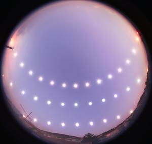
日至和日分
Caption: 這張引人入勝的照片記錄了在2007年12月21日至2008年6月20日期間,太陽在土耳其布爾薩的冬至(下)、春分(中)以及夏至(上)在天空中運動的軌跡。攝影師使用魚眼鏡頭,在這三天中以固定的時間間隔拍攝太陽從日出到日落的位置,生動展示了一年中晝夜長短的變化。太陽每日在天空中的運行軌跡、正午高度、日出和日落的位置,以及白晝的長度,均由地球自轉軸與其繞太陽軌道的傾斜角度決定。這一系列照片拍攝於布爾薩的一座屋頂,當地的地形偶爾會遮擋地平線,為畫面增添了獨特的地域特徵。照片中的方向以北朝上、以南朝下,這組視覺日記成為中北緯地區居民欣賞太陽運行軌跡變化的精彩呈現。
Credit: 通奇·特澤爾/國際天文學聯合會教育辦公室 (CC BY 4.0)
License: CC-BY-4.0 Creative Commons 姓名標示 4.0 國際 (CC BY 4.0) icons
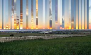
西落幅度
Caption: 這張合成照片拍攝于意大利西西里島的 Gatto Corvino 村,展示了從2016年到2017年冬至到夏至期間,太陽在海面上不同位置的落日景象。中心框為正西方。隨著地球繞太陽公轉,太陽的落下(和升起)位置從夏季的正西(東)方向偏北,變化到冬季的正西(東)方向偏南。在春分和秋分時,白晝和黑夜的長度相等,太陽從正東方升起,正西方落下。太陽在地平線上位置的變化是由於地球繞太陽運行時的自轉軸傾斜。在地球的溫帶地區,夏至和冬至時,正午太陽在地平線以上的高度角分別達到最高和最低值。
Credit: Marcella Giulia Pace/IAU OAE (CC BY 4.0)
License: CC-BY-4.0 Creative Commons 姓名標示 4.0 國際 (CC BY 4.0) icons
Related Diagrams

Solstices and Equinoxes
Caption: This diagram demonstrates the relative positions of the Earth and Sun at the two solstices and two equinoxes. The Earth’s rotation axis is tilted by 23.4° from the axis of its orbit. This means that for half the Earth’s annual orbit around the Sun, the Southern Hemisphere is tilted towards the Sun and the Northern Hemisphere is tilted away from the Sun. During this time the Sun appears to lie below the celestial equator. Due to this at any particular point in the Southern Hemisphere the Sun will appear to be higher above the horizon at a particular time of day and the days will be longer. Conversely during this time, the Sun appears lower in the sky at any particular point in the day in the Northern Hemisphere and the days are shorter.
This effect is most pronounced in late December when the Sun appears at its most southerly point in the sky, corresponding to the longest day of the year in the Southern Hemisphere. This normally occurs on the 21st or 22nd of December (UTC), depending on when the most recent leap year was, but can very occasionally occur on the 20th or 23rd of December. This event is known as the December solstice. As the Sun’s rays hit the Southern Hemisphere at a more perpendicular angle during this time, the Southern Hemisphere is typically warmer in this time of year than at other times of year. This is often referred to as summer in temperate and antarctic regions of the Southern Hemisphere and thus the December solstice is known as the summer solstice. South of the Antarctic Circle at this time the Sun never sets and a Polar Day can last several months. Conversely in the Northern Hemisphere, the Sun’s rays hit the Earth at a more grazing angle than at other times of year so it is colder and this solstice is known as the winter solstice. North of the Arctic Circle the Sun never rises during this time and the Polar Night can last several months.
As the year progresses the Earth moves in its orbit and the tilt of the Earth’s axis moves so it appears more side-on to the Sun. From the perspective of an observer on Earth this means that the Sun moves north in the sky, eventually reaching the celestial equator in late March, This usually occurs on the 20th of March (UTC) but can sometimes occur on the 19th or 21st of March. During this time all places on Earth will experience night and day that is approximately 12 hours long. The Sun’s rays now hit the Southern hemisphere at a more shallow angle than they did in December and hit the Northern Hemisphere at a more perpendicular angle. This means that the Northen Hemisphere will have warmed since December and the Southern Hemisphere cooled. This leads to the March equinox being referred to as the autumn equinox in the Southern Hemisphere and the spring or vernal equinox in the Northern Hemisphere.
As the year progresses further the Sun moves further north on the sky, the Northern Hemisphere days lengthen and the Southern Hemisphere days shorten. By June the Earth’s orbit has progressed to the point where the Northern Hemisphere points towards the Sun and the Southern Hemisphere away from the Sun. At one point between the 20th and 22nd of June (UTC) the Sun reaches its most northerly point in the sky, this is known as June solstice. It is now summer in northern temperate and artic regions so this is known as the summer solstice in the Northern Hemisphere and the winter solstice in the Southern Hemisphere. This is the longest day of the year in the Northern Hemisphere and the shortest day of the year in the Southern Hemisphere. During this time regions north of the Arctic Circle experience a long Polar Day and regions south of the Antarctic Circle experience polar night.
The year progresses further and the Earth moves in its orbit so that the tilt of the Earth’s axis again appears side-on for the Sun. The Sun moves south in the sky and again crosses the celestial equator between the 21st and 24th of September (UTC). At this time all places on the Earth experience equal lengths of day and night. This is known as the September equinox, also called the spring or vernal equinox in the Southern Hemisphere and the autumn equinox in the Northern Hemisphere.
Note the sizes of the Earth, Sun and the Earth’s orbit around the Sun are not to scale in this diagram.
Credit: Maria Cristina Fortuna/IAU OAE
License: CC-BY-4.0 Creative Commons 姓名標示 4.0 國際 (CC BY 4.0) icons

Seasons
Caption: This diagram shows the Earth at the June solstice which is known as the summer solstice in the Northern Hemisphere and the winter solstice in the Southern Hemisphere. The Earth’s axis of rotation is tilted from the axis of the Earth’s orbit around the Sun by 23.4°. Here we see light from the sun represented as parallel lines, in the diagram the Sun would lie far off the right-hand edge. Five lines are marked with angles. These lines hit the Earth at special latitudes. From top to bottom these lines hit the Earth at the North Pole, the Tropic of Cancer, the Equator, the Tropic of Capricorn and the Antarctic Circle. The lines are shown hitting the Earth at the longitude where it is currently noon. For the last four lines, the angles marked show the angle above the horizon (the altitude) which the Sun appears in the sky at at local noon.
At the June solstice, the Sun will appear directly overhead at local noon on every point on the Tropic of Capricorn. By contrast the Sun reaches a maximum altitude of 0° at local noon on every point in the Antarctic Circle. This means the Sun never rises and every point south of the Antarctic Circle experiences a long Polar Night. By contrast the Sun never sets on this day north of the Arctic Circle and the regions here experience a Polar Day. The at the North Pole the Sun will remain at a constant altitude all day. This altitude will be the angle 180°-156.6° (23.4°).
The altitude the Sun appears at is important as it defines how spread out the Sun’s rays are on the Earth’s surface. Look at the thick, faint parallel lines in the background. Notice how at the Tropic of Cancer the area the lines intersect with the Earth’s surface perpendicularly and the line only covers a small part of the Earth’s surface. Now look at a line near the Tropic of Capricorn and see that this intersects with the Earth at a grazing angle and the line is spread out, covering a much wider area of the Earth’s surface. This means that a given amount of light from the Sun that hits the Tropic of Cancer is more concentrated and the same amount of light hitting the Tropic of Capricorn would be more spread out. This leads to more energy per unit area from the Sun hitting the Tropic of Cancer and less energy per unit area hitting the Tropic of Capricorn. This means it will be warmer at the Tropic of Cancer than at the Tropic of Capricorn. It is thus summer at the Tropic of Cancer and winter at the Tropic of Capricorn.
Six months later this situation will be reversed and it will be summer at the Tropic of Capricorn and winter at the Tropic of Cancer.
Credit: Maria Cristina Fortuna/IAU OAE
License: CC-BY-4.0 Creative Commons 姓名標示 4.0 國際 (CC BY 4.0) icons

