词条 季节
描述: 地轴与地球绕太阳运行的轨道并不垂直,而是倾斜 23.4 度。因此,在一天中的某个特定时间,太阳在天空中的视位置随着一年四季变化。平均而言,当太阳在天空中的位置较高时,就会有更多的阳光照射到单位面积的地面上。在一年中,这导致了某些时间段更为温暖或凉爽,这一现象在远离地球赤道的地区更为明显,这就是所谓的季节。北半球的四季与南半球的四季相反:当北半球最大程度地向着太阳倾斜时,就是北半球的夏季,也是南半球的冬季,此时南半球远离太阳倾斜;反之亦然。地球上靠近赤道的许多地区的季节与温带和北极地区的夏冬模式不同。值得注意的是,每个季节的持续时间、开始和结束可能会受到文化习俗和时间段的影响。
相关词条
用其他语言查看该词条
词条和定义状态: 该术语的英文原始定义已通过天文研究人员和教师的审核 该术语及其定义的译文仍待审核
OAE多语言词汇表是由国际天文学联合会(IAU) 天文教育办公室(OAE) 和 国际天文学联合会(IAU) 天文推广办公室(OAO)合作的项目。. 术语和定义由 OAE中心, OAE 国家天文教育协调员(NAECs) 以及其他志愿者共同选择、撰写和审阅。您可以在 找到完整的致谢列表。所有词汇表术语及其定义均根据 Creative Commons CC BY-4.0许可证发布 且版权归属于 “IAU OAE”。
如果您发现此词汇术语或定义中的事实或翻译错误, 请向 发邮件 联系.
其他语言版本
- 阿拉伯语: الفصول
- 德语: Jahreszeiten
- 英语: Seasons
- 西班牙语: Estaciones
- 波斯语: فصلها
- 法语: Saisons
- 意大利语: Le stagioni
- 日语: 季節の変化 (外部链接)
- 巴西葡萄牙语: Estações do ano
- 繁体中文: 季節
相关图表

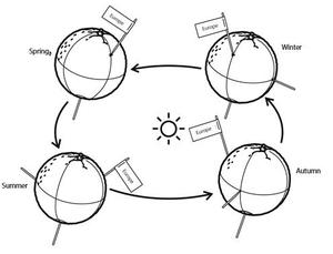
Solstices and Equinoxes
图注: This diagram demonstrates the relative positions of the Earth and Sun at the two solstices and two equinoxes. The Earth’s rotation axis is tilted by 23.4° from the axis of its orbit. This means that for half the Earth’s annual orbit around the Sun, the Southern Hemisphere is tilted towards the Sun and the Northern Hemisphere is tilted away from the Sun. During this time the Sun appears to lie below the celestial equator. Due to this at any particular point in the Southern Hemisphere the Sun will appear to be higher above the horizon at a particular time of day and the days will be longer. Conversely during this time, the Sun appears lower in the sky at any particular point in the day in the Northern Hemisphere and the days are shorter.
This effect is most pronounced in late December when the Sun appears at its most southerly point in the sky, corresponding to the longest day of the year in the Southern Hemisphere. This normally occurs on the 21st or 22nd of December (UTC), depending on when the most recent leap year was, but can very occasionally occur on the 20th or 23rd of December. This event is known as the December solstice. As the Sun’s rays hit the Southern Hemisphere at a more perpendicular angle during this time, the Southern Hemisphere is typically warmer in this time of year than at other times of year. This is often referred to as summer in temperate and antarctic regions of the Southern Hemisphere and thus the December solstice is known as the summer solstice. South of the Antarctic Circle at this time the Sun never sets and a Polar Day can last several months. Conversely in the Northern Hemisphere, the Sun’s rays hit the Earth at a more grazing angle than at other times of year so it is colder and this solstice is known as the winter solstice. North of the Arctic Circle the Sun never rises during this time and the Polar Night can last several months.
As the year progresses the Earth moves in its orbit and the tilt of the Earth’s axis moves so it appears more side-on to the Sun. From the perspective of an observer on Earth this means that the Sun moves north in the sky, eventually reaching the celestial equator in late March, This usually occurs on the 20th of March (UTC) but can sometimes occur on the 19th or 21st of March. During this time all places on Earth will experience night and day that is approximately 12 hours long. The Sun’s rays now hit the Southern hemisphere at a more shallow angle than they did in December and hit the Northern Hemisphere at a more perpendicular angle. This means that the Northen Hemisphere will have warmed since December and the Southern Hemisphere cooled. This leads to the March equinox being referred to as the autumn equinox in the Southern Hemisphere and the spring or vernal equinox in the Northern Hemisphere.
As the year progresses further the Sun moves further north on the sky, the Northern Hemisphere days lengthen and the Southern Hemisphere days shorten. By June the Earth’s orbit has progressed to the point where the Northern Hemisphere points towards the Sun and the Southern Hemisphere away from the Sun. At one point between the 20th and 22nd of June (UTC) the Sun reaches its most northerly point in the sky, this is known as June solstice. It is now summer in northern temperate and artic regions so this is known as the summer solstice in the Northern Hemisphere and the winter solstice in the Southern Hemisphere. This is the longest day of the year in the Northern Hemisphere and the shortest day of the year in the Southern Hemisphere. During this time regions north of the Arctic Circle experience a long Polar Day and regions south of the Antarctic Circle experience polar night.
The year progresses further and the Earth moves in its orbit so that the tilt of the Earth’s axis again appears side-on for the Sun. The Sun moves south in the sky and again crosses the celestial equator between the 21st and 24th of September (UTC). At this time all places on the Earth experience equal lengths of day and night. This is known as the September equinox, also called the spring or vernal equinox in the Southern Hemisphere and the autumn equinox in the Northern Hemisphere.
Note the sizes of the Earth, Sun and the Earth’s orbit around the Sun are not to scale in this diagram.
来源: Maria Cristina Fortuna/IAU OAE
相关活动
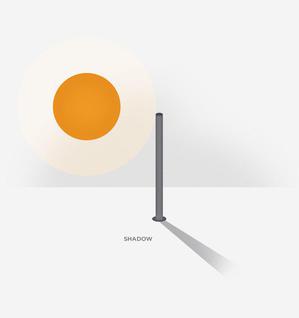
Sun’s Shadow
astroEDU educational activity (links to astroEDU website) Description: Why is the Sun's shadow so important?
License: CC-BY-4.0 知识共享许可协议 署名 4.0 国际 (CC BY 4.0) 图标
标签:
Hands-on
, Shadows
年龄段:
6-8
, 8-10
, 10-12
, 12-14
, 14-16
受教育等级:
非正式
, 初中
, Primary
, 中学
学习领域:
以观察为主
, 结构化探究式学习
费用:
中等成本
时间跨度:
一天
组别大小:
小组
技能:
提出问题
, 传达信息
, 构建解释
, 从证据中进行论证
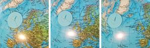
Seasons Around the World
astroEDU educational activity (links to astroEDU website) Description: Demonstrate the seasons on Earth using a model.
License: CC-BY-4.0 知识共享许可协议 署名 4.0 国际 (CC BY 4.0) 图标
标签:
Hands-on
, Model
年龄段:
6-8
, 8-10
, 10-12
受教育等级:
初中
, Primary
学习领域:
建模
, 结构化探究式学习
费用:
中等成本
时间跨度:
45 分钟
组别大小:
小组
技能:
分析和解读数据
, 提出问题
, 构建解释
, 开发和使用模型
, 规划并开展调查
Navigate like a Viking – Use the Sun, not your phone!
astroEDU educational activity (links to astroEDU website) Description: Learn how the Vikings used the sky to navigate at sea with a hands-on activity!
License: CC-BY-4.0 知识共享许可协议 署名 4.0 国际 (CC BY 4.0) 图标
标签:
History
, Geography
, Maps
, Coordinates
, Celestial navigation
年龄段:
12-14
, 14-16
受教育等级:
初中
学习领域:
讨论小组
, 建模
, 结构化探究式学习
费用:
中等成本
时间跨度:
1 小时 30 分钟
组别大小:
小组
技能:
分析和解读数据
, 提出问题
, 传达信息
, 开发和使用模型
, 规划并开展调查
, 使用数学和计算思维

