Glossar-Begriff: Wendekreis
Beschreibung: Die Wendekreise sind zwei Breitengrade auf der Erde. Es gibt den nördlichen Wendekreis (bei 23°26′11,2″ N), auch Wendekreis des Krebses genannt, und den südlichen Wendekreis (bei 23°26′11,2″ S), auch Wendekreis des Steinbocks genannt.
Die Position der Sonne am Himmel im Verhältnis zu den Sternen und anderen Himmelsobjekten ändert sich im Laufe eines Jahres: Sie bewegt sich durch die Sternbilder des Tierkreises. Von der Tagundnachtgleiche im März (Frühlingsäquinoktium) bis zur Tagundnachtgleiche im September (Herbstäquinoktium) befindet sich die Sonne auf der Nordhalbkugel. Zur Sonnenwende im Juni steht die Sonne etwa zur Mittagszeit direkt über dem Wendekreis des Krebses. Zwischen der September-Tagundnachtgleiche und der März-Tagundnachtgleiche befindet sich die Sonne auf der Südhalbkugel. Ungefähr zur Mittagszeit der Dezember-Sonnenwende steht die Sonne direkt über dem Wendekreis des Steinbocks. Während der Tagundnachtgleichen im März und September steht die Sonne direkt über dem Äquator.
Die Region auf der Erde zwischen den beiden Wendekreisen wird oft als " Tropen" bezeichnet. Hier steht die Sonne an zwei Tagen im Jahr zur lokalen Mittagszeit direkt im Zenit.
Der Breitengrad der beiden Wendekreise oberhalb und unterhalb des Äquators ist der Winkel, in dem die Erdachse gegenüber ihrer Umlaufbahn um die Sonne geneigt ist.
Die Wendekreise sind nach den Sternbildern Krebs und Steinbock benannt, welche die Sonne während der Sonnenwenden vor zweitausend Jahren zu durchqueren schien. Aufgrund der Präzession der Erdachse steht die Sonne zu den Sonnenwenden nicht mehr in einem dieser beiden Sternbilder.
Ähnliche Begriffe:
- Tagundnachtgleiche
- Steinbock
- Ekliptik
- Äquator
- Breitengrad
- Jahreszeiten
- Sonnenwende
- Polarkreis
- Krebs
- Präzession
Dieser Begriff in anderen Sprachen
Begriffs- und Definitionsstatus Die Originaldefinition dieses Begriffes auf Englisch wurden von einem forschenden Astronom und einer Lehrkraft bestätigt Die Übersetzung dieses Begriffs und seiner Definition warten auf Prüfung und Bestätigung
The OAE Multilingual Glossary is a project of the IAU Office of Astronomy for Education (OAE) in collaboration with the IAU Office of Astronomy Outreach (OAO). The terms and definitions were chosen, written and reviewed by a collective effort from the OAE, the OAE Centers and Nodes, the OAE National Astronomy Education Coordinators (NAECs) and other volunteers. You can find a full list of credits here. All glossary terms and their definitions are released under a Creative Commons CC BY-4.0 license and should be credited to "IAU OAE".
Wenn dir ein inhaltlicher oder Übersetzungsfehler in diesem Glossarbegriff oder dieser Definition auffallen, bitte kontaktiere uns.
Ähnliche Diagramme

Latitude and Longitude
Unterschrift: Two views of the Earth, one viewing the Northern Hemisphere, one viewing the Southern Hemisphere. The Earth rotates around its axis, an imaginary line that runs through the Earth from the North Pole to the South Pole. The Equator is an imaginary line that is the same distant from both the North Pole and the South Pole.
The positions of two cities, Rome in the Northern Hemisphere and Sydney in the Southern Hemisphere are marked here with red dots. Arrows indicate the two spherical coordinates latitude and longitude.
Latitude marks the position north or south of the equator. Here we can see Rome has the letter N in its latitude as it is in the Northern Hemisphere and Sydney has the letter S in its latitude as it is in the Southern Hemisphere. Latitude can vary from 90° N at the North Pole to 0° at the Equator to 90° S at the South Pole.
Longitude measures the position around the equator. While the choice of the zero point for latitude as the equator seems obvious, the choice of the zero point for longitude is more subjective. By convention the zero point in longitude is the prime meridian which passes through the Royal Greenwich Observatory in the UK. This is marked here as a solid line originating at the North Pole. Longitude is measured in degrees east or west of the prime meridian. As both Rome and Sydney lie to the east of Greenwich, they have the letter E as part of their longitude. Moving west to east, longitude varies from 180° W on the other side of the world from the prime meridian to 0° on the prime meridian before reaching 180° E again on the other side of world from the prime meridian.
This diagram shows the Earth at the December solstice. Two views are presented, one viewing the Northern Hemisphere and one viewing the Southern Hemisphere about nine hours later. The shaded region shows the night side of the Earth, with the day side being lighter. As it is the December solstice, the Sun appears overhead at the Tropic of Capricorn. This is a line of constant latitude at 23°26′09.3″ S. Six months later, at the June solstice, the Sun will appear to be overhead at the Tropic of Cancer at 23°26′09.3″ N. As the Sun appears over the Tropic of Capricorn more of the Southern Hemisphere is illuminated than the Northern Hemisphere. Indeed below the Antarctic Circle (the Polar Circle around the South Pole) the Sun does not set at this time of year leading to a Polar Day. Conversely, north of the Arctic Circle (the Polar Circle around the North Pole) the Sun does not rise at this time of year, leading to a Polar Night.
Bild: Maria Cristina Fortuna/IAU OAE
License: CC-BY-4.0 Creative Commons Namensnennung 4.0 International (CC BY 4.0) Symbole
Ähnliche Aktivitäten
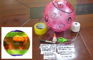
Discover Earth's climate with a balloon
astroEDU educational activity (links to astroEDU website) Description: Discover the secrets of Earth's climate zones with a hands-on experience
License: CC-BY-4.0 Creative Commons Namensnennung 4.0 International (CC BY 4.0) Symbole
Altersgruppen:
8-10
, 10-12
Bildungsniveau:
Middle School
, Primary
Lernbereiche:
Fun activity
, Guided-discovery learning
, Modelling
, Observation based
, Project-based learning
, Structured-inquiry learning
Kosten:
Low Cost
Dauer:
45 mins
Gruppengröße:
Group
Fähigkeiten:
Asking questions
, Constructing explanations
, Developing and using models

