Glossar-Begriff: Tagundnachtgleiche
Beschreibung: Das wahre Äquinoktium ist der Zeitpunkt, an dem die Sonne auf ihrer jährlichen Reise durch die Ekliptik den Himmelsäquator überquert. Das Wort leitet sich vom lateinischen aequinoctium ab, mit aequus (gleich) und nox (Genitiv noctis) (Nacht). Am Tag der Tagundnachtgleiche (auch Äquinoktium genannt) sind die Tages- und Nachtzeiten auf der ganzen Erde ungefähr gleich lang, nicht nur in Äquatornähe. Für einen Beobachter auf der Erde geht die Sonne genau in der östlichen Himmelsrichtung auf, bewegt sich an diesem Tag scheinbar entlang der Linie des Himmelsäquators und geht genau im Westen unter. Es gibt zwei Tagundnachtgleichen pro Jahr, eine um den 20. März und eine um den 23. September. Die März-Tagundnachtgleiche zeigt den scheinbaren Durchgang der Sonne in Richtung der nördlichen Hemisphäre an, die September-Tagundnachtgleiche den scheinbaren Durchgang der Sonne in Richtung Süden.
Ähnliche Begriffe:
Dieser Begriff in anderen Sprachen
Begriffs- und Definitionsstatus Die Originaldefinition dieses Begriffes auf Englisch wurden von einem forschenden Astronom und einer Lehrkraft bestätigt Die Übersetzung dieses Begriffs und seiner Definition warten auf Prüfung und Bestätigung
The OAE Multilingual Glossary is a project of the IAU Office of Astronomy for Education (OAE) in collaboration with the IAU Office of Astronomy Outreach (OAO). The terms and definitions were chosen, written and reviewed by a collective effort from the OAE, the OAE Centers and Nodes, the OAE National Astronomy Education Coordinators (NAECs) and other volunteers. You can find a full list of credits here. All glossary terms and their definitions are released under a Creative Commons CC BY-4.0 license and should be credited to "IAU OAE".
Wenn dir ein inhaltlicher oder Übersetzungsfehler in diesem Glossarbegriff oder dieser Definition auffallen, bitte kontaktiere uns.
Auf anderen Sprachen
- Arabisch: الاعتدال
- Englisch: Equinox
- Spanisch: Equinoccio
- Französisch: Equinoxe
- Italienisch: Equinozio
- Japanisch: 分点 (externer Link)
- Brasilianisches Portugiesisch: Equinócio
- Vereinfachtes Chinesisch: 昼夜平分点
- Traditionelles Chinesisch: 晝夜平分點
Ähnliche Medien
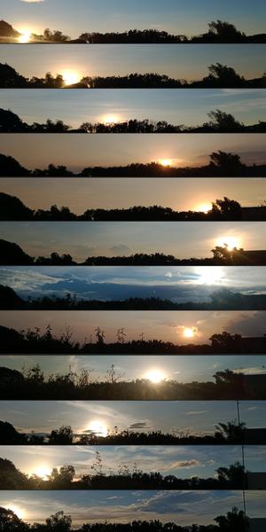
Wo die Sonne jeden Monat untergeht
Unterschrift: Diese Bilderserie wurde mit einem Smartphone in San Rafael in der philippinischen Provinz Bulacan aufgenommen und zeigt die sich im Laufe des Jahres verändernde Position des Sonnenuntergangs bedingt durch die Neigung der Erdachse und die Umlaufbahn der Erde um die Sonne. Jedes dieser von Januar bis Dezember 2022 aufgenommenen Bilder spiegelt die wechselnde Kulisse und Position der Sonne in der Abenddämmerung wider. Achten Sie auf den Laubwechsel und das Erscheinen eines Strommastes im Oktober. Diese Sammlung ist ein visuelles Zeugnis des himmlischen Tanzes zwischen Erde und Sonne und der natürlichen Veränderungen auf der Erde.
Bild: John Paul Pile/IAU OAE (CC BY 4.0)
License: CC-BY-4.0 Creative Commons Namensnennung 4.0 International (CC BY 4.0) Symbole
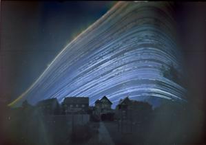
Der Pfad der Sonne
Unterschrift: Dieses bezaubernde Bild, das zwischen dem 21. Juni 2018 und dem 21. Dezember 2018 in Deutschland aufgenommen wurde, ist eine poetische Mischung aus Kunst und Wissenschaft und zeigt den Rhythmus der Natur und den Lauf der Zeit. Es kombiniert Bilder, die im Laufe von sechs Monaten zu verschiedenen Tageszeiten aufgenommen wurden. Jede Kurve zeichnet den Pfad (oder Bogen) der Sonne über den Himmel an einem bestimmten Tag nach. Der schwungvolle Bogen der Sonne wird hierbei durch die Projektion verzerrt, so dass er wie eine Kurve erscheint. Die Position des täglichen Bogens über den Himmel ändert sich mit der jahreszeitlichen Bewegung der Sonne am Himmel. Das Bild wurde mit einer einfachen Lochkamera aus einer Kaffeedose aufgenommen und zeigt die Reise der Sonne im Laufe von sechs Monaten sowie die allmähliche Verschiebung des täglichen Bogens vom Sommer, wenn die Sonne höher am Himmel steht, bis zu ihrem niedrigsten Bogen zur Wintersonnenwende. Lücken in der Sonnenbahn stehen für Tage oder Tageszeiten, an denen die Sonne durch Wolken verdeckt war. Dieses Bild ist ein anschauliches Zeugnis für den Wechsel der Jahreszeiten und zeigt den Tanz der Sonne am Himmel, wenn die Tage kürzer oder länger werden.
Bild: Frank Niessen/IAU OAE (CC BY 4.0)
License: CC-BY-4.0 Creative Commons Namensnennung 4.0 International (CC BY 4.0) Symbole
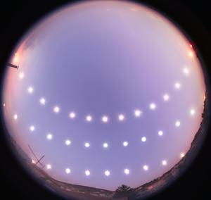
Sonnenwende und Tagundnachtgleiche
Unterschrift: Dieses Bild verdeutlicht den Tagbogen der Sonne am Himmel während der Wintersonnenwende (unten), der Tagundnachtgleiche (Mitte) und der Sommersonnenwende (oben) und wurde zwischen dem 21. Dezember 2007 und dem 20. Juni 2008 in Bursa in der Türkei aufgenommen. Mit einem Fischaugenobjektiv hat der Fotograf die Positionen der Sonne in regelmäßigen Abständen von Sonnenaufgang bis Sonnenuntergang an den drei Tagen eingefangen, um die wechselnden Längen von Tag und Nacht im Laufe des Jahres zu veranschaulichen. Die Veränderungen der täglichen Bahn der Sonne über den Himmel, ihre Höhe zur Mittagszeit, die Positionen von Sonnenauf- und -untergang sowie die Länge eines Tages ergeben sich aus der Neigung der Erdachse relativ zu ihrer Umlaufbahn um die Sonne. Die Bilderserie wurde von einem Dach in Bursa aus aufgenommen und die Landschaft fügt dem Ganzen seine eigene Note hinzu, indem sie hier und da den Horizont verdeckt. Sie stellt in gewisser Weise ein Tagebuch dar, das eine eindrucksvolle Darstellung des Anblicks der Sonnenbahn von mittleren nördlichen Breitengraden aus bietet. Norden ist oben und Süden unten.
Bild: Tunç Tezel/IAU OAE (CC BY 4.0)
License: CC-BY-4.0 Creative Commons Namensnennung 4.0 International (CC BY 4.0) Symbole
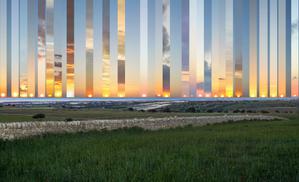
Weiter Ausschlag
Unterschrift: Dieses Bildkomposit wurde vom Dorf Gatto Corvino auf Sizilien aus aufgenommen. Es zeigt den Sonnenuntergang an verschiedenen Punkten über dem Meer zwischen Winter- und Sommersonnenwende in den Jahren 2016 und 2017. Westen liegt genau beim mittleren Bild. Während die Erde die Sonne umkreist, ändert sich die Position der untergehenden (und aufgehenden) Sonne, die im Sommer nördlich und im Winter südlich vom Westpunkt (bzw. Ostpunkt) liegt. Während der Tag- und-Nachtgleiche - wenn Tag und Nacht gleich lang sind - geht die Sonne direkt im Osten auf und direkt im Westen unter. Die wechselnde Position der Sonne am Horizont ist auf die axiale Neigung der Erde auf ihrer Umlaufbahn um die Sonne zurückzuführen. In den gemäßigten Regionen der Erde steht die Sonne zur Mittagszeit bei der Sommersonnenwende am höchsten über dem Horizont und bei der Wintersonnenwende am niedrigsten.
Bild: Marcella Giulia Pace/IAU OAE (CC BY 4.0)
License: CC-BY-4.0 Creative Commons Namensnennung 4.0 International (CC BY 4.0) Symbole
Ähnliche Diagramme
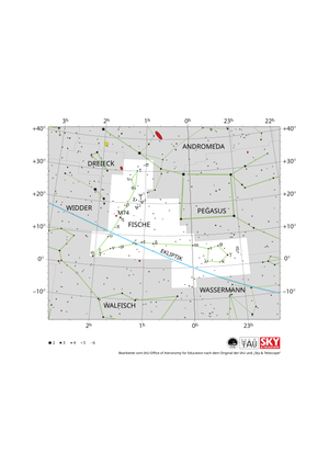
Karte des Sternbilds Fische
Unterschrift: Das Sternbild Fische (lateinisch Pisces) mit seinen hellen Sternen und den umliegenden Sternbildern. Das Sternbild Fische ist umgeben von (im Uhrzeigersinn von oben beginnend) Andromeda, Pegasus, Wassermann, Walfisch, Widder und Dreieck. Die Fische liegen auf der Ekliptik (hier als blaue Linie dargestellt). Dies ist die Bahn, die die Sonne im Laufe eines Jahres scheinbar am Himmel durchläuft. Die Sonne befindet sich von Mitte März bis Mitte April im Sternbild Fische. Somit steht die Sonne auch zur März-Tagundnachtgleiche diesem Sternbild. An diesem Punkt kreuzt die Ekliptik den Himmelsäquator. Die Position der Sonne zur Frühlings-Tagundnachtgleiche dient als Nullpunkt für die Himmelskoordinate der Rektaszension. Auch die anderen Planeten des Sonnensystems sind häufig im Sternbild Fische zu finden.
Die Fische erstrecken sich über den Himmelsäquator und sind daher im Laufe des Jahres von jedem Ort der Erde aus zu sehen. Lediglich in den arktischsten oder antarktischen Regionen der Welt sind einige Teile des Sternbilds möglicherweise nicht sichtbar. Am leichtesten beobachtbar ist das Sternbild Fische abends im Herbst der nördlichen Hemisphäre und im Frühling der südlichen Hemisphäre.
Die Spiralgalaxie M74 vom Typ „Grand Design“ ist in dieser Abbildung mit einem kleinen roten Kreis markiert.
Die y-Achse dieses Diagramms zeigt die Deklination in Grad, wobei Norden oben liegt, und die x-Achse zeigt die Rektaszension in Stunden mit Osten nach links. Die Größe der hier markierten Sterne bezieht sich auf deren scheinbare Helligkeit, ein Maß für die ankommende Strahlungsintensität. Die größeren Punkte repräsentieren hellere Sterne. Die griechischen Buchstaben kennzeichnen die hellsten Sterne des Sternbilds. Diese sind nach Helligkeit geordnet, wobei der hellste Stern mit Alpha bezeichnet wird, der zweithellste mit Beta usw. – wobei diese Reihenfolge nicht immer exakt eingehalten wird. Die gepunkteten Grenzlinien markieren die offiziellen Sternbildgrenzen der IAU, und die durchgezogenen grünen Linien zeigen eine der üblichen Formen, um die Figuren der Sternbilder darzustellen. Weder die Sternbildgrenzen noch die Verbindungslinien zwischen den Sternen sind am realen Himmel zu sehen.
Bild: Bearbeitet vom IAU-Office of Astronomy for Education nach dem Original der IAU und „Sky & Telescope“
License: CC-BY-4.0 Creative Commons Namensnennung 4.0 International (CC BY 4.0) Symbole

Solstices and Equinoxes
Unterschrift: This diagram demonstrates the relative positions of the Earth and Sun at the two solstices and two equinoxes. The Earth’s rotation axis is tilted by 23.4° from the axis of its orbit. This means that for half the Earth’s annual orbit around the Sun, the Southern Hemisphere is tilted towards the Sun and the Northern Hemisphere is tilted away from the Sun. During this time the Sun appears to lie below the celestial equator. Due to this at any particular point in the Southern Hemisphere the Sun will appear to be higher above the horizon at a particular time of day and the days will be longer. Conversely during this time, the Sun appears lower in the sky at any particular point in the day in the Northern Hemisphere and the days are shorter.
This effect is most pronounced in late December when the Sun appears at its most southerly point in the sky, corresponding to the longest day of the year in the Southern Hemisphere. This normally occurs on the 21st or 22nd of December (UTC), depending on when the most recent leap year was, but can very occasionally occur on the 20th or 23rd of December. This event is known as the December solstice. As the Sun’s rays hit the Southern Hemisphere at a more perpendicular angle during this time, the Southern Hemisphere is typically warmer in this time of year than at other times of year. This is often referred to as summer in temperate and antarctic regions of the Southern Hemisphere and thus the December solstice is known as the summer solstice. South of the Antarctic Circle at this time the Sun never sets and a Polar Day can last several months. Conversely in the Northern Hemisphere, the Sun’s rays hit the Earth at a more grazing angle than at other times of year so it is colder and this solstice is known as the winter solstice. North of the Arctic Circle the Sun never rises during this time and the Polar Night can last several months.
As the year progresses the Earth moves in its orbit and the tilt of the Earth’s axis moves so it appears more side-on to the Sun. From the perspective of an observer on Earth this means that the Sun moves north in the sky, eventually reaching the celestial equator in late March, This usually occurs on the 20th of March (UTC) but can sometimes occur on the 19th or 21st of March. During this time all places on Earth will experience night and day that is approximately 12 hours long. The Sun’s rays now hit the Southern hemisphere at a more shallow angle than they did in December and hit the Northern Hemisphere at a more perpendicular angle. This means that the Northen Hemisphere will have warmed since December and the Southern Hemisphere cooled. This leads to the March equinox being referred to as the autumn equinox in the Southern Hemisphere and the spring or vernal equinox in the Northern Hemisphere.
As the year progresses further the Sun moves further north on the sky, the Northern Hemisphere days lengthen and the Southern Hemisphere days shorten. By June the Earth’s orbit has progressed to the point where the Northern Hemisphere points towards the Sun and the Southern Hemisphere away from the Sun. At one point between the 20th and 22nd of June (UTC) the Sun reaches its most northerly point in the sky, this is known as June solstice. It is now summer in northern temperate and artic regions so this is known as the summer solstice in the Northern Hemisphere and the winter solstice in the Southern Hemisphere. This is the longest day of the year in the Northern Hemisphere and the shortest day of the year in the Southern Hemisphere. During this time regions north of the Arctic Circle experience a long Polar Day and regions south of the Antarctic Circle experience polar night.
The year progresses further and the Earth moves in its orbit so that the tilt of the Earth’s axis again appears side-on for the Sun. The Sun moves south in the sky and again crosses the celestial equator between the 21st and 24th of September (UTC). At this time all places on the Earth experience equal lengths of day and night. This is known as the September equinox, also called the spring or vernal equinox in the Southern Hemisphere and the autumn equinox in the Northern Hemisphere.
Note the sizes of the Earth, Sun and the Earth’s orbit around the Sun are not to scale in this diagram.
Bild: Maria Cristina Fortuna/IAU OAE
License: CC-BY-4.0 Creative Commons Namensnennung 4.0 International (CC BY 4.0) Symbole

