بلغات أخرى
- الألمانيّة: Zirkumpolarsterne
- الإنجليزيّة: Circumpolar Stars
- الإسبانيّة: Estrellas circumpolares
- الفرنسيّة: Étoiles circumpolaires
- الإيطاليّة: Stelle circumpolari
- اليابانيّة: 周極星 (رابط خارجي)
- البرتغاليّة البرازيليّة: Estrelas circumpolares
- الصينيّة المبسطة: 拱极星
- الصينيّة التقليدية: 拱極星
وسائط ذات صلة
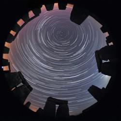
Stone Star Circles, Startrails above Stonehenge, by Till Credner, Germany
الشرح: Second place in the IAU OAE Astrophotography Contest, category Star trails.
Astronomy is one of the oldest (if not the oldest) of the sciences, and as such has connection to various cultures over millennia. This image in a way conveys this relationship by being contextualised in Stonehenge. There is much research into what astronomers call archeoastronomy sites, and how they connect to the sky (for example, seasons, phases of the moon and much more). Civilizations across time and from all over the world have their own views and interpretations of what they see in the sky, and this has been tied not only to culture but also to the people’s day-to-day and seasonal activities. The “concentric circles” which are often referred to as “star trails”, are the result of the apparent motion of the sky, which is in reality due to the rotation of the Earth on its axis. The small dot appearing towards the top center of the image is Polaris – The North or Pole Star. Polaris is only visible to observers in the Northern latitudes. The height of the Pole Star can be used to infer the observer’s actual latitude. Stonehenge is located at around 51° North. This image is taken from one of the most notable ancient sites in the world, brings us back in time, and makes us wonder about the stories told by the people that lived in that place many millennia ago.
المصدر: Till Credner/IAU OAE
License: CC-BY-4.0 المشاع الإبداعي نَسب المُصنَّف 4.0 دولي (CC BY 4.0) أيقونات
التعرض لنصف يوم لنجم الشمال، بقلم فابريزيو ميلاندري، إيطاليا
Dreamlike Starry Sky and Airglow
الشرح: Winner in the 2022 IAU OAE Astrophotography Contest, category Still images of celestial patterns.
This spectacular image shows a range of prominent constellations visible in the night sky over the desert of inner Mongolia, taken in August 2019. The yellowish star in the bottom left side is Arcturus, one of the brightest stars in the night sky, and the brightest in the constellation Boötes. The handle of the Big Dipper points towards this bright star and the Dipper is also visible above Boötes. The Northern Dipper (Bei Dou) is a traditional Chinese constellation. It is considered a chariot in which the Judges for Nobility are sitting. Arcturus is considered a single-star asterism, named the Horn, which forms part of the Chinese super-constellation for the spring, the Azure Dragon of the East. The front of the Northern Dipper points towards the star at the top of the photograph which is now called Polaris, the northern Pole Star. In ancient China, there was no bright star at the pole, so the stars in the nearest vicinity of the pole were considered to belong to the emperor and his family in the constellation the Purple Forbidden Palace. At least as early as mediaeval times, Polaris was considered part of the constellation of the Great Emperor of Heaven.
Corona Borealis is also visible in the top right corner of this image, although not in its completeness. It is called the Coiled Thong in China. With its characteristic semi-circular shape, this is one of the smaller constellations of the 88 modern ones, but also can be traced back at least three or four millennia through the Roman “Crown”, the Greek wedding “Wreath”, and the Babylonian “Asterism of Dignity”. The modern name literally means “Northern Crown” in Latin.
At the upper-right edge of the image, we find the part of the modern constellation Cassiopeia that is considered the Flying Corridor and an Auxiliary Road in ancient China. The W-shape of Cassiopeia is cut off by the edge of the photograph but the constellations to its south and southeast, Andromeda and Perseus, are clearly recognisable. Prominently we see the Andromeda galaxy, the most distant object that is visible to the unaided eye. It is located at the outermost outliers of the band of the Milky Way, which could explain why it has not been mentioned explicitly in ancient star catalogues, as it was mistakenly thought to be part of the Milky Way. The photograph also shows clearly reddish parts of the Milky Way that don’t appear bright to the naked eye, and also open clusters that are formed from the same molecular cloud, i.e., groups of stars with similar ages. This region is part of many big and small asterisms in traditional Chinese uranology.
المصدر: Likai Lin/IAU OAE
License: CC-BY-4.0 المشاع الإبداعي نَسب المُصنَّف 4.0 دولي (CC BY 4.0) أيقونات
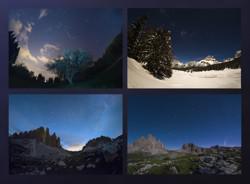
Big Dipper in Four Seasons
الشرح: Winner in the 2022 IAU OAE Astrophotography Contest, category Still images of celestial patterns.
As Earth moves around the Sun, the positions of the stars in the night sky appear to change over the course of the year. This is well exemplified in this mosaic, with images taken in all four seasons throughout 2020 in the region of Veneto, Italy, showing the apparent motion of the Ursa Minor and Ursa Major constellations.
Ursa Minor, the Little Bear, is a constellation of the northern hemisphere, and it contains the northern celestial pole, in our current epoch marked by a bright star called Polaris or the Pole Star. For centuries Polaris has been used for navigation in the northern hemisphere, as it has been almost at the exact pole position for roughly 200 years. In the Middle Ages and antiquity, there was no pole star; the celestial north pole lay in a dark region and the Greeks considered the “Little She-Bear” as a companion of the “Great She-Bear”, which is more easily recognizable. The brightest stars of these constellations were alternatively also considered as chariots by the Greeks, as written in Aratus’s famous didactic poem from the 3rd century before the common era. The most famous asterism in Ursa Major, composed of seven stars, has different names across the (northern) world. While considered as a chariot by the Greeks, it is “The Northern Dipper” in China, and “The Seven Oxen” for the ancient Romans.
It was also the navigational purpose that led to the name The Great She-Bear, Ursa Major; for the Greeks, travelling towards the direction of the horizon above which Ursa Major appears meant moving towards the land of the bears (northern Europe). An animal is clearly recognizable when taking into account all the fainter stars in the vicinity of the seven bright ones. They considered it a female bear because Greek mythology connects this animal with the nymph Callisto, whose story describes the initiation rituals for women.
In the top left, we see an image taken on a spring evening, while the image below shows the same portion of the sky on a summer evening. Going counterclockwise, we see the sky during autumn in the bottom right image, while the top right finally shows this portion of the sky in the winter. Note that the relative positions of Ursa Minor and the Big Dipper don’t change, but all stars appear to be moved in a circle around Polaris. This star pointing due north lies at the point where Earth’s rotational axis intersects the celestial sphere.
The shift of constellations throughout the year is therefore a globe-clock or a globe-calendar, used by ancient civilizations to measure the year, and to predict the changes of seasons. It helps to establish, for instance, the best time for sowing and sailing as winds change with the seasons.
المصدر: Giorgia Hofer/IAU OAE
License: CC-BY-4.0 المشاع الإبداعي نَسب المُصنَّف 4.0 دولي (CC BY 4.0) أيقونات
الدب الأكبر والمذنب الكبير والمذنب نويز C2020 F3
الرسوم التوضيحية المرتبطة

خريطة كوكبة كاسيوبيا او ذات الكرسى
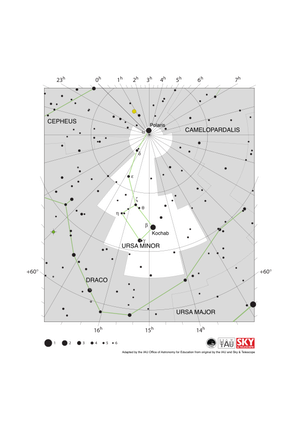
Ursa Minor Constellation Map
الشرح: The constellation Ursa Minor along with its bright stars and its surrounding constellations. Ursa Minor is surrounded by (going clockwise from the top): Cephus, Camelopardalis and Draco. Ursa Minor is notable as its brightest star, Polaris is the northern pole star.
Ursa Minor is visible from the entire northern hemisphere with some parts of the constellation being visible from equatorial regions of the southern hemisphere. It is also circumpolar for temperate and arctic regions of the northern hemisphere. Polaris, lying very close the north celestial pole is circumpolar for the whole of the northern hemisphere. The constellation is most visible in the evenings in the northern hemisphere summer and southern hemisphere winter.
This diagram maps an area around the north celestial pole. Here lines of constant right ascension converge. The right ascension values (in hours) of these lines are marked on the x-axis above and below the diagram. Some of the lines of constant declination (in degrees) are marked on the y-axis. The sizes of the stars marked here relate to the star's apparent magnitude, a measure of its apparent brightness. The larger dots represent brighter stars. The Greek letters mark the brightest stars in the constellation. These are ranked by brightness with the brightest star being labeled alpha, the second brightest beta, etc., although this ordering is not always followed exactly. The dotted boundary lines mark the IAU's boundaries of the constellations and the solid green lines mark one of the common forms used to represent the figures of the constellations. Neither the constellation boundaries, nor the lines joining the stars appear on the sky.
المصدر: Adapted by the IAU Office of Astronomy for Education from the original by IAU/Sky & Telescope
License: CC-BY-4.0 المشاع الإبداعي نَسب المُصنَّف 4.0 دولي (CC BY 4.0) أيقونات

Ursa Major Constellation Map
الشرح: The constellation Ursa Major along with its bright stars and its surrounding constellations. Ursa Major is surrounded by (going clockwise from the top): Draco, Camelopardalis, Lynx, Leo Minor, Leo, Coma Berenices, Canes Venatici and Boötes. Ursa Major is famous for the prominent asterism often known in English as the Big Dipper or the Plough. This prominent northern asterism has a wide variety of names from cultures across the world. While most constellations and asterisms are made up of unrelated stars that randomly appear close together on the sky, five of the stars in the Big Dipper are part of the Ursa Major Moving Group, a group of stars moving through space together that likely formed in the same location 300 million years ago. The two stars on the right-hand end of the Big Dipper on this diagram form a pair of pointer stars that can be used to locate Polaris, the northern pole star which lies in the constellation of Ursa Minor.
Ursa Major is a northern constellation and is visible from northern and equatorial regions. Parts of the constellation are visible from all but the most antarctic parts of the southern hemisphere but not all temperate regions of the southern hemisphere can see all of the Big Dipper. Conversely the Big Dipper and much of the rest of the constellation are circumpolar in arctic and many temperate regions of the northern hemisphere. Ursa Major is most visible in the evening in the northern hemisphere spring and southern hemisphere autumn.
Two prominent galaxies appear in the northern part of this constellation, the spiral galaxy M81 and M82, a possible spiral galaxy whose structure is difficult to observe from the Earth as it appears edge-on. Both are shown here as red ellipses. The planetary nebula M97 (the Owl Nebula) lies in the middle of the constellation and is marked by a green circle superimposed on a plus symbol.
The y-axis of this diagram is in degrees of declination with north as up and the x-axis is in hours of right ascension with east to the left. The sizes of the stars marked here relate to the star's apparent magnitude, a measure of its apparent brightness. The larger dots represent brighter stars. The Greek letters mark the brightest stars in the constellation. These are ranked by brightness with the brightest star being labeled alpha, the second brightest beta, etc., although this ordering is not always followed exactly. The dotted boundary lines mark the IAU's boundaries of the constellations and the solid green lines mark one of the common forms used to represent the figures of the constellations. Neither the constellation boundaries, nor the lines joining the stars appear on the sky.
المصدر: Adapted by the IAU Office of Astronomy for Education from the original by IAU/Sky & Telescope
License: CC-BY-4.0 المشاع الإبداعي نَسب المُصنَّف 4.0 دولي (CC BY 4.0) أيقونات
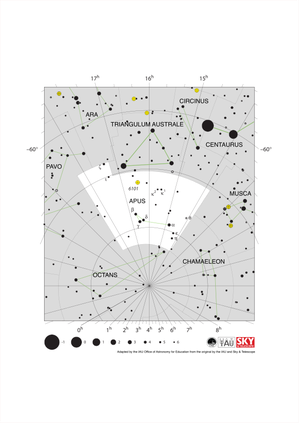
Apus Constellation Map
الشرح: The constellation Apus with its bright stars and surrounding constellations. Apus is surrounded by (going clockwise from the top): Triangulum Australe, Circinus, Musca, Chamaeleon, Octans, Pavo and Ara.
Apus is a southern constellation lying close to the south celestial pole. As such it is visible at some point in the year from the entire southern hemisphere but is only visible from the most equatorial regions of the northern hemisphere. Apus is circumpolar for all temperate and antarctic regions of the southern hemisphere. It is most visible in the evenings in the northern hemisphere summer and southern hemisphere autumn.
The globular cluster NGC 6101 can be found in Apus. It is marked here with a yellow circle with a plus symbol superimposed on it.
This diagram maps an area around the south celestial pole. Here lines of constant right ascension converge. The right ascension values (in hours) of these lines are marked on the x-axis above and below the diagram. Lines of constant declination (in degrees) are marked on the y-axis. The sizes of the stars marked here relate to the star's apparent magnitude, a measure of its apparent brightness. The larger dots represent brighter stars. The Greek letters mark the brightest stars in the constellation. These are ranked by brightness with the brightest star being labeled alpha, the second brightest beta, etc., although this ordering is not always followed exactly. The dotted boundary lines mark the IAU's boundaries of the constellations and the solid green lines mark one of the common forms used to represent the figures of the constellations. Neither the constellation boundaries, nor the lines joining the stars appear on the sky.
المصدر: Adapted by the IAU Office of Astronomy for Education from the original by IAU/Sky & Telescope
License: CC-BY-4.0 المشاع الإبداعي نَسب المُصنَّف 4.0 دولي (CC BY 4.0) أيقونات
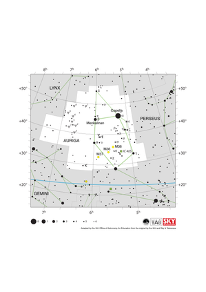
Auriga Constellation Map
الشرح: The constellation Auriga with its bright stars and surrounding constellations. Auriga is surrounded by (going clockwise from the top): Camelopardalis, Perseus, Taurus, Gemini and Lynx. Capella, the brightest star in Auriga, is the sixth brightest star in the night sky.
As a northern constellation, Auriga is visible from the whole of the northern hemisphere at some point in the year. The whole of the constellation is visible to equatorial regions of the southern hemisphere with parts of it visible to temperate southern regions. The whole constellation is circumpolar from arctic regions. The constellation is best viewed in the evening in the late northern hemisphere winter and late southern hemisphere summer.
Auriga lies in the plane of the Milky Way and thus hosts a number of open clusters. Of these M36, M37 and M38 are marked on this diagram with yellow circles. IC 405, also known as the flaming star nebula, is marked here with a green square.
The y-axis of this diagram is in degrees of declination with north as up and the x-axis is in hours of right ascension with east to the left. The sizes of the stars marked here relate to the star's apparent magnitude, a measure of its apparent brightness. The larger dots represent brighter stars. The Greek letters mark the brightest stars in the constellation. These are ranked by brightness with the brightest star being labeled alpha, the second brightest beta, etc., although this ordering is not always followed exactly. The dotted boundary lines mark the IAU's boundaries of the constellations and the solid green lines mark one of the common forms used to represent the figures of the constellations. The blue line at the bottom of the diagram marks the ecliptic. Neither the constellation boundaries, nor the line marking the ecliptic, nor the lines joining the stars appear on the sky.
المصدر: Adapted by the IAU Office of Astronomy for Education from the original by the IAU and Sky & Telescope
License: CC-BY-4.0 المشاع الإبداعي نَسب المُصنَّف 4.0 دولي (CC BY 4.0) أيقونات
الأنشطة المرتبطة
Navigation in the Ancient Mediterranean and Beyond
astroEDU educational activity (links to astroEDU website) Description: Learn the ancient skill of Celestial Navigation
License: CC-BY-4.0 المشاع الإبداعي نَسب المُصنَّف 4.0 دولي (CC BY 4.0) أيقونات
وسوم:
History
, Geography
, Celestial navigation
الفئات العمرية:
14-16
, 16-19
المرحلة التعليمية:
المرحلة المتوسطة
, المرحلة الثانوية
مجالات التعلم:
مجموعات نقاش
, النمذجة
, تعلم منظم قائم على الاستقصاء
التكاليف:
تكلفة منخفضة
المدة:
ساعة ونصف
حجم المجموعة:
جماعي
المهارات:
تحليل البيانات وتفسيرها
, طرح الأسئلة
, توصيل المعلومات
, تطوير النماذج واستخدامها
, تخطيط وتنفيذ التحقيقات
, استخدام الرياضيات والتفكير الحاسوبي

