بلغات أخرى
- الألمانيّة: Polarkreis
- الإنجليزيّة: Polar Circle
- الإسبانيّة: Círculo Polar Ártico
- الفرنسيّة: Cercle polaire
- الإيطاليّة: Circolo polare
- الكوريّة: 극권
- المهاراتية: ध्रुवीय वर्तुळ
- النيبالية: ध्रुवीय वृत्त
- البرتغاليّة البرازيليّة: Círculo Polar
- الصينيّة المبسطة: 极圈
- الصينيّة التقليدية: 極圈
وسائط ذات صلة
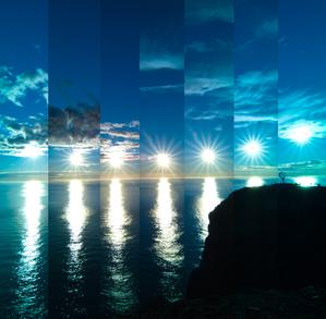
When the Sun Bounces
الشرح: First place winner in the 2023 IAU OAE Astrophotography Contest, category of Still images of sunrise and sunset location over the year.
This image was taken at Norway's North Cape. Owing to the latitude of this location, the Sun never truly sets during the summer months, from around April to August. This results in the unique spectacle of continuous daylight, known as a polar day. This captivating series of images, taken in 2022, showcases the Sun's relentless journey across the horizon every 30 minutes. At its lowest point in the sky, the Sun does not set, but appears to bounce off the horizon. The globe on the far right in the photo stands as a sentinel, marking the northernmost point of the European continental mainland.
المصدر: Milos Obert/IAU OAE (CC BY 4.0)
License: CC-BY-4.0 المشاع الإبداعي نَسب المُصنَّف 4.0 دولي (CC BY 4.0) أيقونات
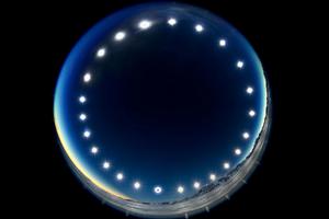
The Eclipse Clock-Eclipse on a Polar Day
الشرح: First place winner in the 2023 IAU OAE Astrophotography Contest, category of Still images of day arcs of the Sun and Solargraphs.
Constructed by combining multiple images over the course of a 24-hour period, the image was captured in Union Glacier, Antarctica, during the total solar eclipse of 4 December 2021, and showcases the day arc of the Sun. It illustrates the unique phenomenon of a polar day, during which the Sun travels around the sky without setting. During polar days, areas within the polar circles experience 24 hours of continuous daylight, and the Sun doesn’t set for an extended period. The image also offers a rare perspective of a solar eclipse, where the Moon passes between the Sun and Earth, and as viewed from Earth. This can be seen in the lower image of the Sun, where the Moon covers the solar disc.
المصدر: Stephanie Ziyi Ye/IAU OAE (CC BY 4.0)
License: CC-BY-4.0 المشاع الإبداعي نَسب المُصنَّف 4.0 دولي (CC BY 4.0) أيقونات
الرسوم التوضيحية المرتبطة

Latitude and Longitude
الشرح: Two views of the Earth, one viewing the Northern Hemisphere, one viewing the Southern Hemisphere. The Earth rotates around its axis, an imaginary line that runs through the Earth from the North Pole to the South Pole. The Equator is an imaginary line that is the same distant from both the North Pole and the South Pole.
The positions of two cities, Rome in the Northern Hemisphere and Sydney in the Southern Hemisphere are marked here with red dots. Arrows indicate the two spherical coordinates latitude and longitude.
Latitude marks the position north or south of the equator. Here we can see Rome has the letter N in its latitude as it is in the Northern Hemisphere and Sydney has the letter S in its latitude as it is in the Southern Hemisphere. Latitude can vary from 90° N at the North Pole to 0° at the Equator to 90° S at the South Pole.
Longitude measures the position around the equator. While the choice of the zero point for latitude as the equator seems obvious, the choice of the zero point for longitude is more subjective. By convention the zero point in longitude is the prime meridian which passes through the Royal Greenwich Observatory in the UK. This is marked here as a solid line originating at the North Pole. Longitude is measured in degrees east or west of the prime meridian. As both Rome and Sydney lie to the east of Greenwich, they have the letter E as part of their longitude. Moving west to east, longitude varies from 180° W on the other side of the world from the prime meridian to 0° on the prime meridian before reaching 180° E again on the other side of world from the prime meridian.
This diagram shows the Earth at the December solstice. Two views are presented, one viewing the Northern Hemisphere and one viewing the Southern Hemisphere about nine hours later. The shaded region shows the night side of the Earth, with the day side being lighter. As it is the December solstice, the Sun appears overhead at the Tropic of Capricorn. This is a line of constant latitude at 23°26′09.3″ S. Six months later, at the June solstice, the Sun will appear to be overhead at the Tropic of Cancer at 23°26′09.3″ N. As the Sun appears over the Tropic of Capricorn more of the Southern Hemisphere is illuminated than the Northern Hemisphere. Indeed below the Antarctic Circle (the Polar Circle around the South Pole) the Sun does not set at this time of year leading to a Polar Day. Conversely, north of the Arctic Circle (the Polar Circle around the North Pole) the Sun does not rise at this time of year, leading to a Polar Night.
المصدر: Maria Cristina Fortuna/IAU OAE
License: CC-BY-4.0 المشاع الإبداعي نَسب المُصنَّف 4.0 دولي (CC BY 4.0) أيقونات
الأنشطة المرتبطة

Discover Earth's climate with a balloon
astroEDU educational activity (links to astroEDU website) Description: Discover the secrets of Earth's climate zones with a hands-on experience
License: CC-BY-4.0 المشاع الإبداعي نَسب المُصنَّف 4.0 دولي (CC BY 4.0) أيقونات
الفئات العمرية:
8-10
, 10-12
المرحلة التعليمية:
المرحلة المتوسطة
, المرحلة الابتدائية
مجالات التعلم:
نشاط ممتع
, تعلم استكشافي موجه
, النمذجة
, قائم على الملاحظة
, التعلم القائم على المشاريع
, تعلم منظم قائم على الاستقصاء
التكاليف:
تكلفة منخفضة
المدة:
45 دقيقة
حجم المجموعة:
جماعي
المهارات:
طرح الأسئلة
, صياغة التفسيرات
, تطوير النماذج واستخدامها

