This page describes an image Mare Crisium - Sea of Crises
Download File ( image 6.78 MB)
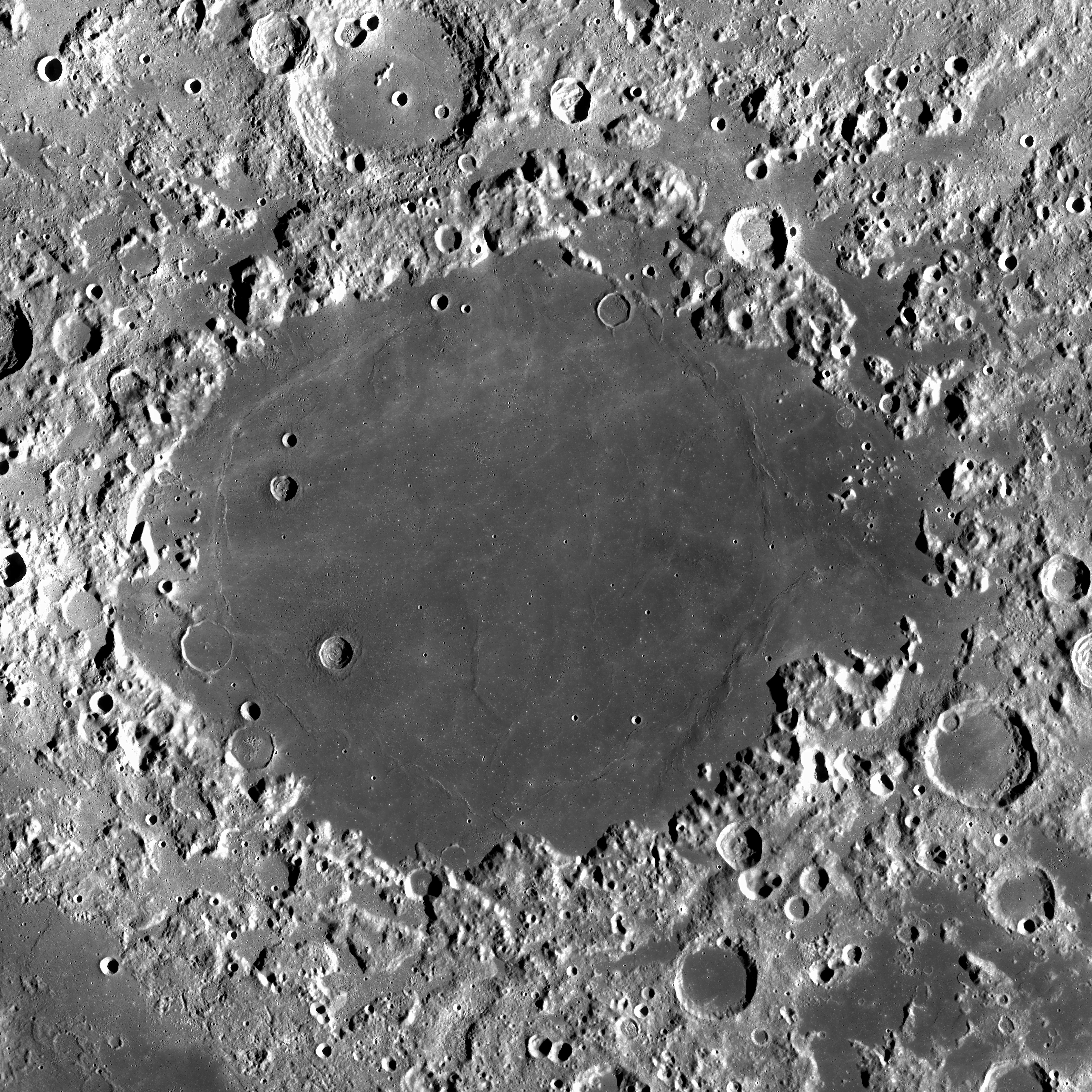
Image caption:
The image shows the lunar Mare Crisium, the “Sea of Crises,” as seen by NASA’s Lunar Reconnaissance Orbiter in 2015. The photo size is 750 × 750 km, about the size of Germany. Mare Crisium is located in the Moon’s Crisium basin, near the great Mare Tranquillitatis on the near side of the Moon. It is visible from Earth and is characterized by a relatively smooth and flat surface surrounded by cliffs and highlands. The basin that now contains the Mare Crisium was formed by a massive impact event likely during the Nectarian period approximately 3.9 billion years ago. During this time in lunar history, major basins including the Crisium basis were formed by large impact events. Later in lunar history, the basin was flooded by lava to form the dark and flat plain we see today. Its floor is about 1.8 kilometers below the typical lunar surface level. The study of lunar maria provides insights into the volcanic history and impact processes that have affected the Moon and other celestial objects.
Scroll to captions in other languages
Image credit: NASA, Lunar Reconnaissance Orbiter Credit Link
Related glossary terms:
Mare
, Moon
Categories:
Solar System
Image license: Public Domain Public Domain icons
The media file captions presented on the OAE website were written, translated and reviewed by a collective effort from the OAE, the OAE Centers and Nodes, the OAE National Astronomy Education Coordinators (NAECs) and other volunteers. You can find a full list of credits for our translation project here. All media file captions are released under a Creative Commons CC BY-4.0 license and should be credited to "IAU OAE". The media files themselves may have different licenses (see above) and should be credited as listed above under "credit".
If you notice a factual error in this caption or an error in any of its translations then please get in touch.
Captions in Different Languages:
Image caption: Das Bild zeigt das Mare Crisium, das "Meer der Krisen", wie es vom Lunar Reconnaissance Orbiter der NASA im Jahr 2015 aufgenommen wurde. Das Foto ist 750 × 750 km groß, etwa so groß wie Deutschland. Das Mare Crisium befindet sich im Crisium-Becken des Mondes, in der Nähe des großen Mare Tranquillitatis auf der Nahseite des Mondes. Es ist von der Erde aus sichtbar und zeichnet sich durch eine relativ glatte und flache Oberfläche aus, die von Klippen und Hochländern umgeben ist. Das Becken, in dem sich heute das Mare Crisium befindet, wurde durch einen massiven Einschlag gebildet, der wahrscheinlich während der Nektarzeit vor etwa 3,9 Milliarden Jahren stattfand. In dieser Zeit der Mondgeschichte wurden große Becken, darunter auch die Crisium-Basis, durch große Einschläge geformt. Später in der Mondgeschichte wurde das Becken von Lava überflutet und bildete die dunkle und flache Ebene, die wir heute sehen. Der Boden des Beckens liegt etwa 1,8 Kilometer unter dem typischen Niveau der Mondoberfläche. Die Untersuchung von Mondmarien gibt Aufschluss über die vulkanische Geschichte und Einschlagsprozesse, die den Mond und andere Himmelskörper beeinflusst haben.
Image credit: NASA, Lunar Reconnaissance Orbiter
Related glossary terms: Mare , Mond Caption translation status: Not yet approved by a reviewer
Caption translators: Emma Krojanski
Image caption: L'image montre la région lunaire Mare Crisium, la "mer des Crises", vue par la sonde Lunar Reconnaissance Orbiter de la NASA en 2015. La taille de la photo est de 750 × 750 km, soit environ la taille de l'Allemagne. Mare Crisium est située dans le bassin Crisium de la Lune, près de la grande Mare Tranquillitatis sur la face proche de la Lune. Elle est visible depuis la Terre et se caractérise par une surface relativement lisse et plate, entourée de falaises et de hauts plateaux. Le bassin qui contient aujourd'hui Mare Crisium a été formé par un impact massif, probablement pendant la période Nectarienne, il y a environ 3,9 milliards d'années. À cette époque de l'histoire lunaire, les principaux bassins, dont celui de la mer des Crises, ont été formés par de grands impacts. Plus tard dans l'histoire lunaire, le bassin a été inondé par la lave pour former la plaine sombre et plate que nous voyons aujourd'hui. Son fond se trouve à environ 1,8 kilomètre sous le niveau moyen de la surface lunaire. L'étude des maria lunaires permet de mieux comprendre l'histoire volcanique et les processus d'impact qui ont affecté la Lune et d'autres objets célestes.
Image credit: NASA, Lunar Reconnaissance Orbiter
Related glossary terms: Lune , Mer Caption translation status: Not yet approved by a reviewer
Caption translators: Olivier Bonneton
Image caption: L'immagine mostra il Mare Crisium lunare, il "Mare delle crisi", visto dal Lunar Reconnaissance Orbiter della NASA nel 2015. Le dimensioni della foto sono 750 × 750 km, circa le dimensioni della Germania. Il Mare Crisium si trova nel bacino Crisium della Luna, vicino al grande Mare della Tranquillità sul lato vicino della Luna. È visibile dalla Terra ed è caratterizzato da una superficie relativamente liscia e piatta circondata da scogliere e altopiani. Il bacino che oggi contiene il Mare Crisium si è formato in seguito a un massiccio impatto avvenuto probabilmente durante il periodo Nettariano, circa 3,9 miliardi di anni fa. In questo periodo della storia lunare, i principali bacini, tra cui quello di Crisium, si sono formati in seguito a grandi impatti. Più tardi nella storia lunare, il bacino fu inondato dalla lava per formare la pianura scura e piatta che vediamo oggi. Il suo fondo si trova a circa 1,8 chilometri sotto il livello tipico della superficie lunare. Lo studio dei bacini lunari fornisce informazioni sulla storia vulcanica e sui processi di impatto che hanno interessato la Luna ed altri oggetti celesti.
Image credit: NASA, Orbiter di ricognizione lunare
Related glossary terms: Luna , Mare Caption translation status: Not yet approved by a reviewer
Caption translators: Giuliana Giobbi
Image caption: A imagem mostra o Mare Crisium lunar, o "Mar das Crises", conforme observado pelo Lunar Reconnaissance Orbiter, da NASA, em 2015. O tamanho da foto é de 750 × 750 km, aproximadamente o tamanho da Alemanha. O Mare Crisium está localizado na bacia Crisium da Lua, próximo ao grande Mare Tranquillitatis no lado visível da Lua. Ele é visível da Terra e é caracterizado por uma superfície relativamente lisa e plana cercada por penhascos e planaltos. A bacia que agora contém o Mare Crisium foi formada por um evento de grande impacto, provavelmente durante o período Nectariano, há aproximadamente 3,9 bilhões de anos. Durante esse período da história lunar, as principais bacias, incluindo a base do Crisium, foram formadas por grandes eventos de impacto. Mais tarde na história lunar, a bacia foi inundada por lava, formando a planície escura e plana que vemos hoje. Sua superfície está cerca de 1,8 quilômetro abaixo do nível típico da superfície lunar. O estudo dos mares lunares fornece informações sobre a história vulcânica e os processos de impacto que afetaram a Lua e outros objetos celestes.
Image credit: NASA, Lunar Reconnaissance Orbiter
Related glossary terms: Lua , Mares lunares Caption translation status: Not yet approved by a reviewer
Caption translators: Eduardo Monfardini Penteado


.png)