Download File ( image 1.76 MB)
Download PDF File (PDF file 165.78 kB)
Also available in black and white
Download File ( image 483.06 kB)
Download PDF File (PDF file 136.70 kB)
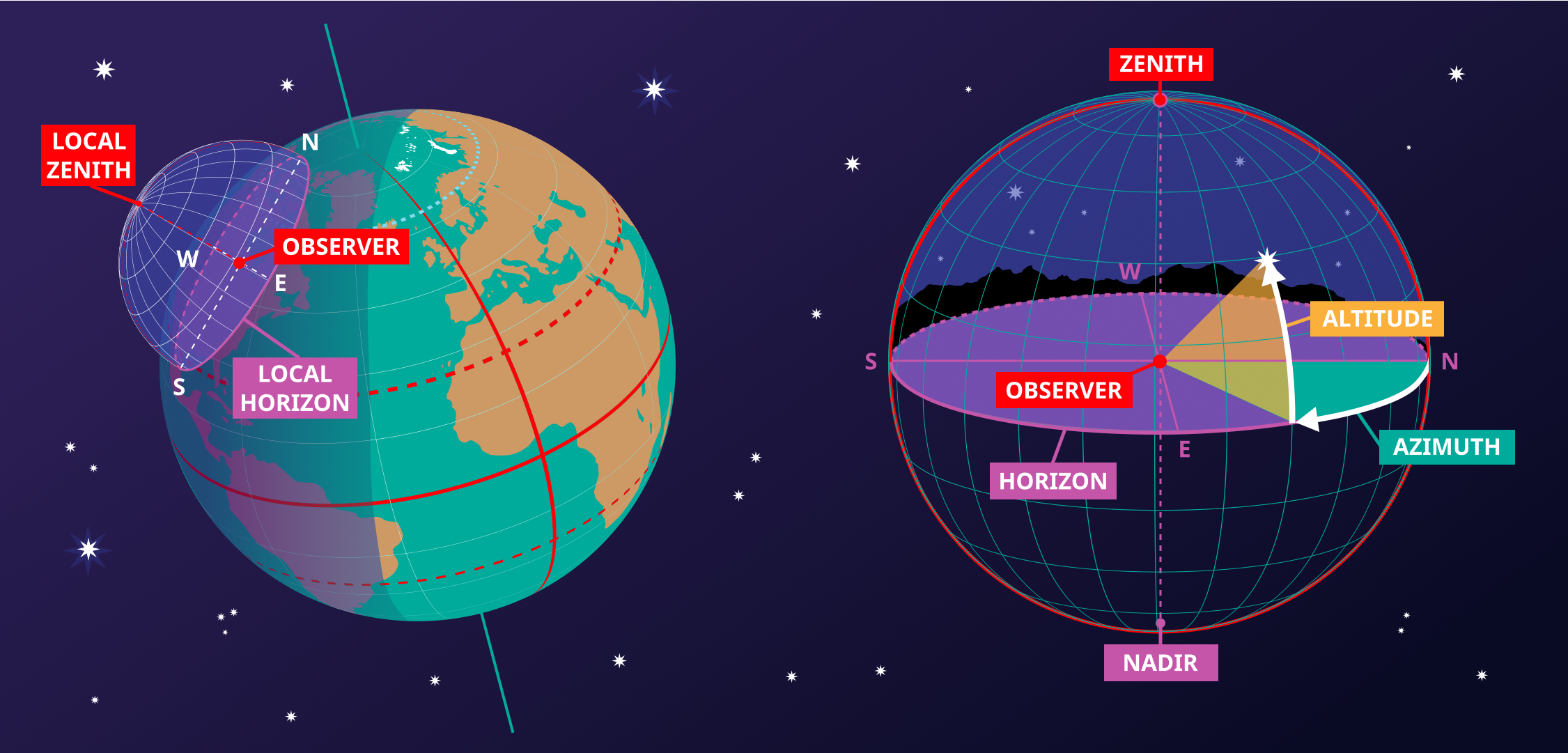
Diagram caption:
This image shows the horizontal coordinate system of an observer on Earth. On the right we see the coordinate system in the local context of the observer. The observer appears here as a point surrounded by the celestial sphere. The ground appears as a plane, while the Earth is round, we can approximate the ground in the area around the observer as a plane. The line where this plane intersects with the celestial sphere is the horizon. The point directly above the observer is the zenith, the point directly below the observer is the nadir which is hidden by the ground.
Two coordinates define this coordinate system, altitude and azimuth, hence the reason this sometimes called an alt-az coordinate system. The altitude is zero at the horizon, maximum (90°) at the zenith and minimum (-90°) at the nadir. Azimuth is the angle around the horizon. Most commonly this is defined to be zero in the direction of north. Any point on the celestial sphere can be defined by these two coordinates. However what objects appear on these position will depend on the time and the location of the observer.
On the left-hand part of the diagram, we can see that when we put the observer and their local horizontal coordinate system in a global context, that the parts of the sky the observer can see depend on their position on the Earth and on the rotation of the Earth. The zenith points perpendicular to the Earth's surface so the position on the sky the zenith and nadir correspond to is dependent on the observer's latitude. The horizon also depends on the observer's position on the Earth.
Diagram credit: Maria Cristina Fortuna/IAU OAE.
Diagram translation status: Not yet approved by a reviewer
Diagram license: Creative Commons تخصیص 4.0 بینالمللی (CC BY 4.0) Creative Commons تخصیص 4.0 بینالمللی (CC BY 4.0) icons
Related glossary terms:
Azimuth
, Horizon
, Nadir
, Zenith
, ارتفاع
Categories:
Naked Eye Astronomy
, Observational Astronomy
Want to make your own translation or version of this diagram? Then
download the SVG
version of this diagram in English (237.62 kB). You can edit this using
software like Inkscape (free) or Adobe Illustrator
(proprietary). Just remember to credit the author of the original appropriately.
Also available in black and white ( image 237.62 kB).
You can also make your own version or translation of this diagram by adding adding text to a version of
this diagram with no text. Just download one of the following files:
Download Text-Free File ( image 578.50 kB)
Download Text-Free PDF File (PDF file 175.90 kB)
Also available in black and white:
Download Text-Free File ( image 450.79 kB)
Download Text-Free PDF File (PDF file 141.72 kB)


