Término del glosario: Satélite Artificial
Descripción: Un satélite artificial es un dispositivo fabricado por el ser humano que se envía al espacio para orbitar la Tierra u otros objetos del Sistema Solar, donde la gravedad lo mantiene en órbita. Los satélites artificiales pueden construirse para realizar diversas tareas, como tomar fotografías aéreas de la Tierra que ayuden a los meteorólogos a predecir el tiempo, o tomar imágenes de cuerpos astronómicos y galaxias lejanas, lo que ayuda a los científicos a comprender mejor el sistema cósmico. Los satélites artificiales también se utilizan principalmente para las comunicaciones en todo el mundo y para encontrar la propia posición, por ejemplo, el Sistema de Posicionamiento Global (GPS). El primer satélite artificial fue lanzado al espacio en 1957 por la Unión Soviética, con el nombre de Sputnik 1.
Términos relacionados:
Ver este término en otros idiomas
Estado del término y la definición: La definición original de este término en inglés ha sido aprobada por unastrónomo o astrónoma investigadora y un docente La traducción de este término y su definición aún están pendientes de aprobación
El Glosario multilingüe de la OAE es un proyecto de la Oficina de Astronomía para la Educación de la UAI (OAE) en colaboración con la Oficina de Divulgación de Astronomía de la UAI (OAO). Los términos y definiciones fueron seleccionados, redactados y revisados gracias al esfuerzo colectivo de la OAE, los Centros y Nodos de la OAE, los Coordinadores Nacionales de Educación Astronómica (NAECs) y otros voluntarios. Puedes encontrar una lista completa de créditos aquí. Todos los términos del glosario y sus definiciones se publican bajo la licencia Creative Commons CC BY-4.0 y deben atribuirse a la "IAU OAE".
Si detectas algún error de contenido o de traducción en este término del glosario o en ladefinición, ponte en contacto con nosotros.
En otros idiomas
- Árabe: قمر اصطناعي
- Alemán: Künstlicher Satellit
- Inglés: Artificial Satellite
- Francés: Satellite artificiel
- Hindi: कृत्रिम उपग्रह
- Italiano: Satellite artificiale
- Japonés: 人工衛星 (enlace externo)
- Coreano: 인공 위성
- Maratí: कृत्रिम उपग्रह
- Portugués de Brasil: Satélite artificial
- Chino simplificado: 人造卫星
- Chino tradicional: 人造衛星
Contenidos relacionados
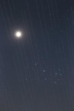
Satellite swarm versus night sky beauty, by Torsten Hansen, Germany
Pie de foto: Third place in the 2021 IAU OAE Astrophotography Contest, category Light pollution.
This image of Venus and the Pleiades also shows the tracks of the Starlink satellites. These satellites which are located at an altitude of approximately 550 kilometres, are part of an ever-growing constellation of satellites aimed to provide worldwide internet access. The reflective surfaces of the satellites, coupled with the fact that they are orbiting around the Earth, means that astronomical observations which require very long exposures capture “tracks” of the satellites in their images. Astronomical images used for scientific research are not usable because the measurements and data will contain these “tracks”. Because the number of satellites is expected to grow, it is likely that in the near future there will be no place on Earth where these satellites will not be visible crossing the sky. This is a new type of light pollution that seems to be an upcoming problem we will have to deal with, as these satellites might prevent optimal observation of the sky.
Crédito: Torsten Hansen/IAU OAE
License: CC-BY-4.0 Creative Commons Reconocimiento 4.0 Internacional (CC BY 4.0) íconos
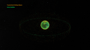
Space debris orbiting the Earth
Pie de foto: This animation shows objects orbiting the Earth. The data date from February 2024 and are taken from space-track.org which maintains a public catalogue of objects tracked by the United States Space Command (USSPACECOM).
At first in this video we see green dots, each representing one of the 31,000 human-made objects orbiting Earth. These include both operational and decommissioned satellites, used rocket stages from space launches, and fragments larger than 10cm created by collisions or explosions. Later in the video, some of the green dots are replace by orange dots, each of these representing one of the 9,300 operational satellites orbiting the Earth. Note that since February 2024 more satellites and rockets have been launched in to space and some objects will have fallen back to Earth, so these numbers will have changed.
We see two main groups of objects. The first are those objects orbiting close to the Earth, objects in low Earth orbit. These include communication satellites (many from the satellite constellations used to provide satellite internet services), Earth observation satellites, military satellites, two operational space stations and other objects such as rocket stages and other debris.
More distant from Earth we see a thin ring of satellites. These are in geostationary orbit. This is a special orbit where the orbital period matches the rotation period of the Earth. This means that a satellite in geostationary orbit stays above the same point on the equator and, when observed from the side of the Earth facing the satellite, will appear to stay at a position on the sky that does not change over time. Because of this, geostationary orbit is used by many communications satellites as a satellite dish on Earth used to receive or transmit a signal to that satellite can point in a fixed direction and does not need to dynamically track the satellite. Geostationary orbit is also used by weather observation satellites.
Crédito: NASA's Scientific Visualization Studio
enlace de crédito
License: PD Dominio público íconos
Actividades relacionadas
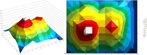
Valleys Deep and Mountains High
astroEDU educational activity (links to astroEDU website) Description: Learn how radar altimetry from satellites works and how to put landscapes on paper.
License: CC-BY-4.0 Creative Commons Reconocimiento 4.0 Internacional (CC BY 4.0) íconos
Etiquetas:
Maps
, Earth observation
, Sentinel
, Copernicus
, Remote sensing
, Altimetry
, Radar
Rango de edades:
14-16
, 16-19
Nivel educativo:
Educación secundaria
, Secondary
Áreas de aprendizaje:
Grupos de discusión
, Modelización
, Aprendizaje basado en la investigación estructurada
Costos:
Coste medio
Duración:
2 horas
Tamaño del grupo:
Grupo
Competencias:
Analizar e interpretar datos
, Plantear preguntas
, Comunicar información
, Desarrollar y utilizar modelos
, Utilizar las matemáticas y el pensamiento computacional
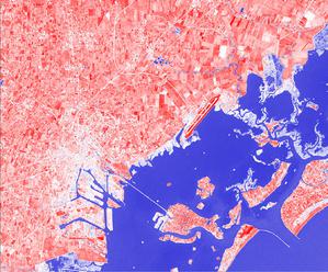
A View from Above
astroEDU educational activity (links to astroEDU website) Description: How do satellites take images of the Earth surface and how do we analyse and use them?
License: CC-BY-4.0 Creative Commons Reconocimiento 4.0 Internacional (CC BY 4.0) íconos
Etiquetas:
Maps
, Climate
, Landsat
, Earth observation
, Sentinel
, Copernicus
, Remote sensing
, Vegetation
Rango de edades:
14-16
, 16-19
Nivel educativo:
Educación secundaria
, Secondary
Áreas de aprendizaje:
Aprendizaje basado en la investigación estructurada
Costos:
Bajo coste
Duración:
1 hora y 30 minutos
Tamaño del grupo:
Grupo
Competencias:
Analizar e interpretar datos
, Plantear preguntas
, Comunicar información
, Elaborar explicaciones
, Desarrollar y utilizar modelos
, Participar en debates basados en pruebas
, Utilizar las matemáticas y el pensamiento computacional
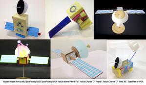
Build Your Own Artificial Satellite
astroEDU educational activity (links to astroEDU website) Description: Build a satellite to learn what they are made of and their uses.
License: CC-BY-4.0 Creative Commons Reconocimiento 4.0 Internacional (CC BY 4.0) íconos
Etiquetas:
Art
, Creativity
, Hands-on
, Model
Rango de edades:
8-10
Nivel educativo:
Primaria
Áreas de aprendizaje:
Grupos de discusión
, Clase interactiva
, Modelización
Costos:
Bajo coste
Duración:
1 hora y 30 minutos
Tamaño del grupo:
Grupo
Competencias:
Comunicar información
, Desarrollar y utilizar modelos
Where on Earth am I?
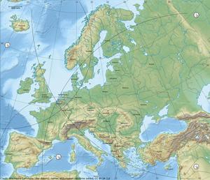
astroEDU educational activity (links to astroEDU website) Description: How do satellite-based positioning and GPS navigation work?
License: CC-BY-4.0 Creative Commons Reconocimiento 4.0 Internacional (CC BY 4.0) íconos
Etiquetas:
Clocks
, Geography
, Maps
, GPS
, Countries
, Speed of light
, Galileo
Rango de edades:
14-16
Nivel educativo:
Educación secundaria
Áreas de aprendizaje:
Aprendizaje por descubrimiento guiado
, Resolución de problemas
Costos:
Bajo coste
Duración:
1 hora y 30 minutos
Tamaño del grupo:
Grupo
Competencias:
Analizar e interpretar datos
, Plantear preguntas
, Comunicar información
, Elaborar explicaciones
, Desarrollar y utilizar modelos
, Utilizar las matemáticas y el pensamiento computacional